
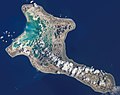
Tabuaeran, also known as Fanning Island, is an atoll that is part of the Line Islands of the central Pacific Ocean and part of the island nation of Kiribati...
14 KB (1,354 words) - 15:22, 10 May 2024

has the largest land area of any atoll in the world. Only Kiritimati, Tabuaeran, and Teraina have a permanent population. Besides the 11 confirmed atolls...
19 KB (1,513 words) - 16:02, 10 September 2024
the second round in five electoral districts (Arorae, Betio, Fanning (Tabuaeran), North Tabiteuea and Tarawa Teinainano). If voting trends from the first...
36 KB (1,739 words) - 12:33, 3 September 2024
360967°W / 3.849868; -159.360967 Aontenaa is a settlement located on Tabuaeran atoll, Kiribati. Paelau is to the north; with Tenenebo to the south. In...
928 bytes (79 words) - 08:18, 4 September 2023
trans-Pacific telegraph cable from Bamfield, British Columbia, to Fanning Island (Tabuaeran) in the Line Islands, and from Fiji to Fanning Island, thus completing...
137 KB (13,942 words) - 00:23, 14 September 2024
Napari or Napali is a settlement located at the north end of Tabuaeran atoll, Kiribati. In the 2002 census 194 people were recorded as living in Napali...
921 bytes (91 words) - 08:57, 18 December 2023
159.361599°W / 3.857048; -159.361599 Paelau is a settlement located on Tabuaeran atoll, Kiribati. It is located on the western side of the atoll, south...
1,023 bytes (111 words) - 14:58, 25 April 2022
-159.36472 Tereitaki is a settlement located towards the north end of Tabuaeran atoll, Kiribati. Napari is the northernmost settlement; with Betania to...
828 bytes (84 words) - 00:46, 14 January 2024
The current names are from the Gilbertese language with one exception, Tabuaeran. Except for Tarawa and Tabiteuea atolls http://islands.unep.ch/IKQ.htm...
11 KB (176 words) - 15:59, 10 September 2024
159.36472°W / 3.86000; -159.36472 Tenenebo is a settlement located on Tabuaeran atoll, Kiribati. Aontenaa is to the north; with Tereitannano to the south...
716 bytes (70 words) - 15:38, 19 August 2020
816668; -159.325475 Mwanuku or Manuku or Eten is a settlement located on Tabuaeran atoll, Kiribati. Eten is the most south village on the atoll. Aramari...
918 bytes (88 words) - 03:03, 31 May 2024

Kiritimati/Christmas Island Malden Island Phoenix Islands Starbuck Island Tabuaeran/Fanning Island Teraina/Washington Island Vostok Island List of islands...
43 KB (4,275 words) - 13:55, 13 June 2024
Antarctica Channel Rock (disambiguation), various rocks English Channel (Tabuaeran), "A deep opening, thereafter called the English Channel, was blasted...
5 KB (662 words) - 21:45, 25 August 2024

) Acrocephalus aequinoctialis pistor. (Distributed across Teraina and Tabuaeran.) This bird has a lot of medicinal and symbolic significance. Its feathers...
4 KB (270 words) - 03:31, 24 June 2024
suggested that Kiritimati was used intermittently (likely by people from Tabuaeran to the north) as a place to gather resources such as birds and turtles...
70 KB (7,722 words) - 18:44, 28 August 2024

(Gambier Islands), Tubuai (Austral Islands), Rarotonga (Cook Islands), and Tabuaeran (Northern Line Islands). The first Europeans to reach the Marquesas may...
55 KB (5,854 words) - 21:39, 6 September 2024

parts of the Line Islands belonging to Kiribati, including Kiritimati, Tabuaeran and Teraina, are the first parts of the world to welcome the New Year...
166 KB (18,525 words) - 09:38, 8 September 2024
Aramari is a settlement located on Tabuaeran atoll, Kiribati. Tereitannano is to the north; with Mwanuku or Eten to the south. In the 2010 census 244...
830 bytes (63 words) - 00:42, 6 September 2023

Airlines Destinations Air Kiribati Tabuaeran, Teraina Fiji Airways Honolulu, Nadi Nauru Airlines Tarawa...
8 KB (649 words) - 13:51, 26 August 2024
International Airport - Hub Kiritimati - Cassidy International Airport Tabuaeran - Tabuaeran Airport Teraina - Teraina Airfield As of January 2024, the Air Kiribati...
14 KB (1,193 words) - 21:24, 5 September 2024
Island Fanning, Kansas, United States Fanning, Missouri, United States Tabuaeran, also known as Fanning Atoll or Fanning Island, one of the Line Islands...
810 bytes (139 words) - 21:24, 23 July 2020
36472°W / 3.86000; -159.36472 Tereitannano is a settlement located on Tabuaeran atoll, Kiribati. Tenenebo is to the north; with Aramari to the south....
897 bytes (79 words) - 03:03, 31 May 2024

Due to this, Britain actively sought to acquire Fanning Island (now Tabuaeran in Kiribati) to use for a midpoint power regeneration / relay station...
8 KB (867 words) - 15:02, 9 September 2024

Anote Tong (category People from Tabuaeran)
raise "global awareness on the threat posed by climate change". Born in Tabuaeran, Line Islands, he is the third of six children of Tong Ting Hai, a Chinese...
25 KB (2,452 words) - 00:43, 20 August 2024

Palmyra Atoll (97 g·m−2), and low shark numbers have been observed at Tabuaeran and Kiritimati. The percentage of the total fish biomass on the reef is...
25 KB (2,723 words) - 21:06, 10 September 2024
Candidate Anote Tong Nabuti Mwemwenikarawa Party PTK Independent Popular vote 15,664 8,149 Percentage 64.29% 33.44% Home Island Tabuaeran...
3 KB (175 words) - 13:16, 24 August 2024

Honduras–US Treaty of 1972 Tabuaeran Oceania Fanning Island 3°51′36″N 159°21′52″W / 3.86000°N 159.36444°W / 3.86000; -159.36444 (Tabuaeran) Kiribati Treaty...
19 KB (442 words) - 14:03, 30 September 2023

However, population density (177 per km2) is three times as high as on Tabuaeran and vastly more than on the much larger (300-plus km2) Kiritimati with...
28 KB (3,347 words) - 05:47, 13 August 2024
the rickety Iola, against prevailing winds and currents, to Fanning (Tabuaeran), a nearby atoll in Kiribati, to restock — a voyage close to impossible...
9 KB (1,170 words) - 17:03, 20 August 2024
Nikunau Nonouti North Tabiteuea (Tabiteuea) Onotoa South Tabiteuea (Tabiteuea) Tamana Phoenix Islands Canton Line Islands Kiritimati Tabuaeran Teraina...
3 KB (196 words) - 05:28, 30 January 2024