
Jacques Nicolas Bellin (French pronunciation: [ʒak nikɔla bɛlɛ̃]; 1703 – 21 March 1772) was a French hydrographer, geographer, and member of the French...
9 KB (1,149 words) - 08:04, 26 January 2025
Sieur le Rouge map c. 1740 John Gibson (cartographer), map c. 1758 Jacques-Nicolas Bellin (1703–1772), chief cartographer to the French navy William Bligh...
30 KB (3,143 words) - 08:46, 14 February 2025

islands first appear on a 1742 proof of a map published in 1744 by Jacques-Nicolas Bellin, who used Charlevoix's journal as a source. That map and those based...
8 KB (751 words) - 06:01, 18 September 2024

d'Argenville Antoine-Gaspard Boucher d'Argis Arnulphe d'Aumont Jacques-Nicolas Bellin Jacques-François Blondel Claude Bourgelat Jean-François-Henri Collot...
9 KB (1,014 words) - 18:13, 2 February 2025

Tamarix senegalensis. The settlement was mentioned in the 1747 map by Jacques-Nicolas Bellin as "Terrafal". In 1917, the municipality of Tarrafal was separated...
3 KB (272 words) - 19:17, 25 April 2024

time the parish boundaries were laid out. The French cartographer Jacques-Nicolas Bellin (1703–1772) draw several editions of a chart of the island of Grenada...
6 KB (441 words) - 03:00, 15 July 2024

riviere aux Outardes came in use following its appearance on maps by Jacques-Nicolas Bellin in 1744 and 1764. English maps from the end of the 18th century...
5 KB (332 words) - 01:10, 9 December 2024

detachment of French troops in 1729. — Jacques-Nicolas Bellin A map of the Ohio River valley, drawn by Bellin from observations by de Lery, is in Pierre...
82 KB (7,756 words) - 17:12, 22 February 2025

Livingstone followed 140 years later. A map from c. 1750 drawn by Jacques Nicolas Bellin for Abbé Antoine François Prevost d'Exiles marks the falls as "cataractes"...
41 KB (4,405 words) - 20:29, 18 February 2025
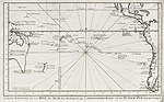
Map of the south Pacific by Jacques-Nicolas Bellin, including "Lands sawn by Davis" at about 27°S (1753)...
5 KB (526 words) - 10:29, 6 July 2024
Nicola Buhagiar, Maltese painter (b. 1698) 1762 – Nicolas Louis de Lacaille, French priest, astronomer, and academic (b. 1713) 1772 – Jacques-Nicolas...
57 KB (5,625 words) - 07:35, 18 February 2025

the website of the Bibliothèque nationale de France. For example: Jacques-Nicolas Bellin, Tableau des pavillons que la pluspart des nations arborent à la...
17 KB (2,078 words) - 12:59, 28 January 2025
British-Czechoslovak chess player Jacques-Nicolas Bellin (1703–1772), French hydrographer and geographer Melissa Bellin, also known as Spice; dancer, valet...
819 bytes (125 words) - 15:41, 21 February 2023

captain in 1720. It was mentioned as "Palmera" in the 1747 map by Jacques-Nicolas Bellin. "2010 Census results". Instituto Nacional de Estatística Cabo Verde...
2 KB (176 words) - 17:56, 29 December 2020
Meroni, Comoros appears on a 1748 map by French hydrographer Jacques Nicolas Bellin...
36 KB (4,405 words) - 02:13, 21 February 2025
6635C. doi:10.1073/pnas.1522714113. PMC 4914162. PMID 27247383. Brucato, Nicolas; Fernandes, Veronica; Mazières, Stéphane; Kusuma, Pradiptajati; Cox, Murray...
24 KB (3,032 words) - 21:18, 23 January 2025

post appears on 18th century French maps by Royal hydrographer Jacques-Nicolas Bellin as "Fort Caministogoyan". The post was abandoned in 1758 or 1760...
10 KB (1,321 words) - 15:48, 12 February 2025

of the Cape Verde islands 1747 French-Dutch map of Cape Verde by Jacques Nicolas Bellin The 1781 battle of Porto Praya by Marquis de Rossel Mindelo (originally...
33 KB (3,935 words) - 14:33, 25 January 2025

Map of Anjouan (1748) by French hydrographer Jacques Nicolas Bellin....
28 KB (3,415 words) - 12:27, 12 January 2025

Turks and Caicos on a 1764 map by Jacques Nicolas Bellin...
41 KB (4,759 words) - 08:31, 31 January 2025

Statistics Division. Accessed online October 3, 2007. (French) Bellin, Jacques-Nicolas (n.d.). "Carte de l'Amerique septentrionale (Map of Northern America...
10 KB (600 words) - 18:28, 24 February 2025
Map of French Guiana by cartographer Jacques-Nicolas Bellin (1763)...
16 KB (2,017 words) - 20:21, 20 April 2024

1744 map of eastern North America by Jacques-Nicolas Bellin, showing "Vill. Atiga" on the Ohio ("Oyo") River, probably the first representation of Kittanning...
39 KB (4,656 words) - 06:27, 10 January 2025

in his 1780 engraving, "A Plan of the Harbour of St. Augustin". Jacques-Nicolas Bellin, Royal French Hydrographer, refers to the coquina tower as a "Batise"...
27 KB (3,126 words) - 18:06, 17 June 2023
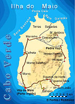
bay was mentioned as "Ghelloons" in the 1747 map by Jacques-Nicolas Bellin. Jacques-Nicolas Bellin (1747). "Carte des Isles du Cap Verd = Kaart van de...
981 bytes (64 words) - 21:02, 30 December 2020

cartographers of the late 18th century. In 1773 Bonne succeeded Jacques Nicolas Bellin as Royal Cartographer to France in the office of the Hydrographer...
2 KB (223 words) - 17:26, 10 October 2023

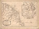
1773 map by Jacques-Nicolas Bellin showing leMouchoir Carré, tres peu connu = very little known as if with islands, which in reality do not exist...
3 KB (221 words) - 14:50, 28 October 2024
The headland was mentioned as Pt. Ghelongo in the 1747 map by Jacques-Nicolas Bellin. The lighthouse at Ponta Jalunga was constructed in 1891. It is...
3 KB (194 words) - 23:12, 4 September 2024

Ribeira Brava.: 14 It was mentioned as Terrafal in the 1747 map by Jacques-Nicolas Bellin. It became an anchorage for whaling ships in the 19th century, and...
3 KB (303 words) - 18:48, 29 December 2020
settlement was mentioned as "Rivera das Baras" in the 1747 map by Jacques-Nicolas Bellin. António Mascarenhas Monteiro, former president of the Republic...
2 KB (139 words) - 17:49, 29 December 2020