
The Klondike Highway is a highway that runs from the Alaska Panhandle through the province of British Columbia and the territory of Yukon in Canada, linking...
11 KB (869 words) - 13:07, 6 January 2022

Dempster Highway, also referred to as Yukon Highway 5 and Northwest Territories Highway 8, is a highway in Canada that connects the Klondike Highway in Yukon...
13 KB (1,069 words) - 03:03, 26 January 2024

The Klondike (/ˈklɒndaɪk/; from Hän Tr'ondëk 'hammerstone water') is a region of the territory of Yukon, in northwestern Canada. It lies around the Klondike...
12 KB (1,081 words) - 09:24, 24 June 2024
List of Alaska Routes (redirect from List of Alaska numbered highways)
Fairbanks. The Klondike Highway, built in 1978, was unnumbered until 1998, when it was given its designation during the centennial of the Klondike Gold Rush...
15 KB (544 words) - 19:25, 19 June 2024
of Yukon Klondike Highway, connecting Skagway, Alaska to Dawson City, Yukon Klondike Hills, a mountain range near the Klondike River Klondike River, the...
3 KB (340 words) - 07:32, 30 March 2023

Reindeer Lake.) Klondike River (left) flowing into the Yukon River (top and right) at Dawson City Klondike River crossing Dempster Highway (downstream) Mouth...
4 KB (196 words) - 14:59, 20 September 2023

southern Yukon with a layer of ash which can still be seen along the Klondike Highway, and which forms part of the oral tradition of First Nations peoples...
64 KB (5,222 words) - 03:08, 4 July 2024

Alaska Highway 98 on the American side joins Yukon Highway 2 on the Canadian side. The border is near the summit of White Pass on the Klondike Highway, where...
5 KB (490 words) - 19:42, 22 June 2024
Mile 925.5 to 926.9, now Parent Road (east end overlooks Alaska Highway/Klondike Highway junction) Mile 927.2 to 927.7, now Echo Valley Road Mile 928 to...
49 KB (4,665 words) - 00:10, 17 June 2024

of Klondike Gold Rush International Historical Park. Paddle-wheel riverboats continued to ply the river until the 1950s, when the Klondike Highway was...
46 KB (3,677 words) - 01:43, 22 June 2024
Un-officially named "Fraser Lake." Lake located at Mile Post 27.7 and at Klondike Highway Kilometer 36.5, adjacent to the Fraser station. Big Kalzas Lake [Car...
443 KB (33,930 words) - 03:25, 26 June 2024

the Klondike Highway, near the junction with the Silver Trail, from which it is about 53 km (33 mi) southwest of Mayo. A Yukon government highway maintenance...
9 KB (397 words) - 03:44, 10 September 2023

Fraser, British Columbia (category Klondike Gold Rush)
Fraser is a location on the Klondike Highway in northwestern British Columbia, Canada. The community has no businesses or permanent residents aside from...
6 KB (244 words) - 02:54, 11 February 2024

Dawson City (category Klondike Gold Rush)
fall 1955, with Whitehorse along a road that now forms part of the Klondike Highway. In 1978, another kind of buried treasure was discovered with the Dawson...
49 KB (4,312 words) - 00:06, 24 May 2024
Nation. It is 74 km (46 mi) south-southeast by the Alaska Highway and the Klondike Highway from Whitehorse. The south end of the Tagish Road is in Carcross...
18 KB (1,250 words) - 04:47, 9 June 2024
Pelly Crossing is a community in Yukon, Canada. It lies where the Klondike Highway crosses the Pelly River. It is the home of the Selkirk First Nation...
10 KB (599 words) - 13:21, 2 May 2024

Watson Lake, Yukon on the Alaska Highway to Carmacks, Yukon on the Klondike Highway. It is 583 km (362 mi) long and mostly gravel-surfaced. It serves the...
3 KB (280 words) - 19:35, 9 February 2020
a hot meal. Remains of a Klondike Gold Rush roadhouse can be seen today south of Carmacks, Yukon, along the Klondike Highway. One built in 1902 is the...
8 KB (939 words) - 11:47, 18 June 2024

in British Columbia and Windy Arm in the west, mostly in Yukon. The Klondike Highway runs along Windy Arm south of Carcross. Bennett Lake flows into Tagish...
4 KB (299 words) - 11:12, 5 November 2023

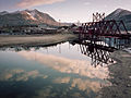
300-foot (91 m) asymmetric single-pylon cable-stayed bridge on the Klondike Highway that spans the Moore Creek Gorge in the borough of Skagway, Alaska...
9 KB (864 words) - 19:40, 19 May 2024

Silver Trail (redirect from Yukon Highway 11)
officially Yukon Highway 11, is a highway in the Canadian territory of Yukon connecting the communities of Mayo and Keno City with the Klondike Highway at Stewart...
3 KB (210 words) - 17:39, 1 November 2020
outskirts of Whitehorse attempting to hitch a lift northwards on the Klondike Highway. The race restarted on Day 15 from Dawson City to the Rocky Mountain...
56 KB (3,667 words) - 10:34, 2 June 2024

Tagish Road (redirect from Tagish Highway)
Yukon Highway 8) is a 33-mile (53-kilometre) road, now hard surfaced, that links Jakes Corner on the Alaska Highway with Carcross, Yukon on the Klondike Highway...
2 KB (152 words) - 21:14, 2 July 2023

village of Mayo. The river is crossed by the Klondike Highway at the village of Stewart Crossing, and the highway parallels the river westward for about 56...
6 KB (447 words) - 15:16, 25 March 2023

Yukon, Canada, on the Yukon River along the Klondike Highway, and at the west end of the Robert Campbell Highway from Watson Lake. The population is 588 (Canada...
20 KB (1,153 words) - 01:59, 30 April 2024

Yellowknife Highway branches out from Mackenzie Highway and connects it to Yellowknife. Dempster Highway is the continuation of Klondike Highway. It starts...
79 KB (6,210 words) - 04:52, 5 July 2024

located along Bonanza Creek Road 13 kilometres (8.1 mi) south of the Klondike Highway near Dawson City, Yukon, where it is preserved as one of the National...
18 KB (2,017 words) - 06:50, 13 June 2024

Chilkoot Trail (category Klondike Gold Rush)
railroad. The other branch, the Log Cabin cut-off, connects with the Klondike Highway, but was closed by Parks Canada in 2010. Bennett consists of a campground...
33 KB (4,342 words) - 02:07, 10 June 2024

Five Finger Rapids were a common obstacle for gold seekers during the Klondike Gold Rush; the Yukon River was originally believed to be unnavigable above...
2 KB (319 words) - 20:54, 21 March 2023
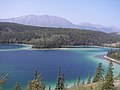
notable for its intense green colour. It is located on the South Klondike Highway at kilometre 117.5 (mile 73.5), measured from Skagway, Alaska. The...
3 KB (219 words) - 08:41, 12 March 2024