
The shapefile format is a geospatial vector data format for geographic information system (GIS) software. It is developed and regulated by Esri as a mostly...
16 KB (1,638 words) - 17:12, 18 August 2024
Aviation Organization (ICAO). Note that the cited ICAO source gives the shapefile coordinates for each FIR, and also its page source gives a list of current...
19 KB (131 words) - 20:56, 3 March 2024

appropriate article: "2016 Boundaries". Municipal Demarcation Board (Shapefile). 2016. "Community Survey 2016". Statistics South Africa (Data file)....
12 KB (98 words) - 16:02, 29 October 2023

established in 2000. "2016 Boundaries". Municipal Demarcation Board (Shapefile). 2016. "Community Survey 2016". Statistics South Africa (Data file)....
13 KB (103 words) - 16:36, 15 January 2024

established in 2000. "2016 Boundaries". Municipal Demarcation Board (Shapefile). 2016. "Community Survey 2016". Statistics South Africa (Data file)....
17 KB (118 words) - 19:15, 9 August 2024
from the original on 2014-02-07. Retrieved 2010-08-03. "2009 TIGER/Line Shapefiles Technical Documentation" (PDF). United States Census Bureau. 2009. Archived...
9 KB (879 words) - 10:00, 18 July 2024

Department of Transportation (October 2016). "State DOT Road Inventory" (ESRI Shapefile). Retrieved July 31, 2019. Hawaii Department of Transportation (December...
130 KB (665 words) - 17:33, 14 August 2024

established in 2000. "2016 Boundaries". Municipal Demarcation Board (Shapefile). 2016. "Community Survey 2016". Statistics South Africa (Data file)....
5 KB (74 words) - 12:21, 12 April 2024
Calgary. 2012. Retrieved February 4, 2013. "Community Boundaries" (Esri shapefile). City of Calgary. Retrieved February 5, 2013. City of Calgary (2004)...
6 KB (328 words) - 13:49, 24 January 2023

like the Esri file geodatabase, proprietary but public formats like the Shapefile and the original KML, open source formats like GeoJSON, and formats created...
28 KB (3,096 words) - 22:00, 25 August 2024

statistics; this page is less detailed than the "packet". GIS (ESRI) shapefile of the district boundaries KML (Google Earth) file of the district boundaries...
14 KB (404 words) - 11:11, 26 August 2024
2008. U.S. Census Bureau, Geography Division, "Cartographic Boundary Shapefiles – Places (Incorporated Places and Census Designated Places)". Cartographic...
16 KB (1,776 words) - 10:56, 30 August 2024
established in 2000. "2016 Boundaries". Municipal Demarcation Board (Shapefile). 2016. "Community Survey 2016". Statistics South Africa (Data file)....
8 KB (97 words) - 16:03, 29 October 2023
Retrieved 21 January 2017. "2016 Boundaries". Municipal Demarcation Board (Shapefile). 2016. "Community Survey 2016". Statistics South Africa (Data file)....
86 KB (229 words) - 23:45, 5 July 2024

established in 2000. "2016 Boundaries". Municipal Demarcation Board (Shapefile). 2016. "Community Survey 2016". Statistics South Africa (Data file)....
9 KB (87 words) - 16:10, 29 October 2023
National Transfer Format file OV2 – TomTom POI overlay file SHP – ESRI shapefile TAB – MapInfo TAB format GeoTIFF – Geographically located raster data:...
129 KB (14,050 words) - 13:58, 31 August 2024
file format during the 1980s and 1990s, including the Esri coverage and Shapefile. The second era in the history of GIS, starting in the mid-1970s, was...
6 KB (847 words) - 21:35, 10 April 2024

of Ministry of Local Government Members of Parliament District Profile At Statoids.com Uganda Bureau of Statistics Uganda - UBOS Districts Shapefile...
16 KB (328 words) - 03:10, 15 July 2024

PEATMAP is a GIS shapefile dataset that shows a distribution of peatlands that covers the entire world...
76 KB (8,263 words) - 23:22, 7 August 2024

publications are required to be released into the public domain. The TIGER/Line shapefile data includes complete coverage of the contiguous United States, Alaska...
4 KB (515 words) - 21:03, 23 June 2024

established in 2000. "2016 Boundaries". Municipal Demarcation Board (Shapefile). 2016. "Community Survey 2016". Statistics South Africa (Data file)....
7 KB (68 words) - 15:10, 27 December 2023
(NTF) – National Transfer Format (mostly used by the UK Ordnance Survey) Shapefile – open, hybrid vector data format using SHP, SHX and DBF files (by ESRI)...
3 KB (238 words) - 10:42, 18 July 2024

established in 2000. "2016 Boundaries". Municipal Demarcation Board (Shapefile). 2016. "Community Survey 2016". Statistics South Africa (Data file)....
9 KB (89 words) - 16:02, 29 October 2023
The digital ecoregions layer is available for download as an ArcGIS Shapefile. The Marine Ecoregions of the World classification defines 232 marine...
6 KB (568 words) - 10:08, 31 January 2023
geographical tool in the United States, indicated by the publication of a USGS shapefile that maps the regions of the original work and the National Park Services's...
15 KB (1,766 words) - 15:04, 31 August 2024

Aviation Organization (ICAO). Note that the cited ICAO source gives the shapefile coordinates for each FIR, and also its page source gives a list of current...
28 KB (938 words) - 22:02, 19 June 2024
format Geography Markup Language KML format, compatible with Google Earth Shapefile TCX, Garmin Training Center XML Standards NMEA 0183 NMEA 2000 Software...
6 KB (578 words) - 22:56, 25 July 2024
2020. Aboriginal Affairs and Northern Development Canada (4 June 2015). "Post-1975 Treaties (Modern Treaties)" (Shapefile). Open Government. About IRC...
12 KB (445 words) - 00:08, 1 August 2023
SHTML SSI-enabled HTML file Server Side Includes SHX Shape entities ESRI shapefile AutoCAD ArcGIS SIC S.I.C.K. Source File SIG Signature file gpg, PopMail...
29 KB (603 words) - 23:58, 24 June 2024

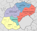
various different colours. "2016 Boundaries". Municipal Demarcation Board (Shapefile). 2016. "Community Survey 2016". Statistics South Africa (Data file)....
7 KB (72 words) - 08:23, 30 November 2023