
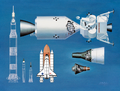
Landsat 8 is an American Earth observation satellite launched on 11 February 2013. It is the eighth satellite in the Landsat program; the seventh to reach...
23 KB (2,255 words) - 19:27, 15 May 2024

eventually renamed to Landsat 1 in 1975. The most recent, Landsat 9, was launched on 27 September 2021. The instruments on the Landsat satellites have acquired...
41 KB (3,814 words) - 06:10, 29 June 2024
Landsat 7 is the seventh satellite of the Landsat program. Launched on 15 April 1999, Landsat 7's primary goal is to refresh the global archive of satellite...
13 KB (1,361 words) - 00:46, 25 June 2024

Landsat 9 is an Earth observation satellite launched on 27 September 2021 from Space Launch Complex-3E at Vandenberg Space Force Base on an Atlas V 401...
10 KB (858 words) - 20:25, 9 May 2024

Landsat 5 was a low Earth orbit satellite launched on March 1, 1984, to collect imagery of the surface of Earth. A continuation of the Landsat Program...
11 KB (1,099 words) - 03:33, 11 January 2024

remote sensing instrument aboard Landsat 8, built by Ball Aerospace & Technologies. Landsat 8 is the successor to Landsat 7 and was launched on February...
6 KB (608 words) - 18:24, 17 May 2024

Satellite imagery (section Landsat)
Landsat 5, thermal infrared imagery was also collected (at coarser spatial resolution than the optical data). The Landsat 7, Landsat 8, and Landsat 9...
27 KB (3,127 words) - 12:06, 18 June 2024

Landsat 1 (LS-1), formerly named ERTS-A and ERTS-1, was the first satellite of the United States' Landsat program. It was a modified version of the Nimbus...
12 KB (1,139 words) - 12:58, 9 April 2024

August 2010, and the temperature was deduced from radiance measured by the Landsat 8 and other satellites. It was discovered during a National Snow and Ice...
28 KB (3,111 words) - 12:40, 9 July 2024
List of Atlas launches (2020–2029) (section Landsat 9)
launch of next Landsat to September 2021". Spaceflight Now. 7 September 2020. Retrieved 8 September 2020. "NASA, USGS Begin Work on Landsat 9 to Continue...
37 KB (2,114 words) - 22:40, 2 July 2024

of scan swath. All sensors aboard the Landsat series of satellites used the whisk broom design until Landsat 8 which used a push broom sensor. Push broom...
2 KB (191 words) - 16:21, 14 January 2024
Landsat 4 is the fourth satellite of the Landsat program. It was launched on July 16, 1982, with the primary goal of providing a global archive of satellite...
12 KB (1,237 words) - 15:31, 23 April 2024
failed Landsat 7, launched April 1999, operational Landsat 8, launched February 2013, operational Landsat 9, launched September 2021, operational Living With...
48 KB (3,943 words) - 12:08, 12 June 2024

The Thematic Mapper (TM) sensor on Landsat 4 and Landsat 5 included a thermal (6th) band. Landsat 8 and Landsat-9 also acquires thermal data in two 10...
13 KB (1,272 words) - 14:24, 19 February 2024

in 2006 From the International Space Station on February 7, 2022 With Landsat 8 on March 20, 2022 Center for Menominee Language, Culture, and Art, Language...
15 KB (1,498 words) - 15:13, 13 June 2024
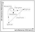
weighted sum of the Landsat bands (without the thermal channel 6), where each band is multiplied by the specific coefficients. Early Landsat products: Brightness...
3 KB (465 words) - 17:41, 19 January 2024

spatial resolution allows for continued collaboration with the SPOT-5 and Landsat-8 missions, with the core focus being land classification. Designed and...
20 KB (1,849 words) - 04:16, 15 July 2024
Synop Report Summary". Ogimet.com. Retrieved 5 August 2019. "NASA-USGS Landsat 8 Satellite Pinpoints Coldest Spots on Earth". Archived from the original...
11 KB (1,199 words) - 04:38, 26 March 2024

News, 9 December 2013. The Coldest Place on Earth: -90 °C and below from Landsat 8 and other satellite thermal sensors Archived 3 March 2016 at the Wayback...
189 KB (10,521 words) - 20:51, 14 July 2024

2021 satellite image of Bir Tawil (outlined in red) by Landsat 8...
13 KB (1,063 words) - 06:18, 21 May 2024

Bang Kachao as captured by the Landsat 8 satellite...
3 KB (376 words) - 04:09, 25 March 2024

D24102. Bibcode:2009JGRD..11424102T. doi:10.1029/2009JD012104. "NASA-USGS Landsat 8 Satellite Pinpoints Coldest Spots on Earth". NASA. 9 December 2013. Retrieved...
10 KB (1,159 words) - 15:20, 12 February 2024

Thomas fire from space – Los Angeles Daily News USGS Earth Explorer - Landsat and Sentinel-2 satellite imagery NASA Worldview - MODIS and Suomi NPP near...
125 KB (10,099 words) - 06:25, 16 April 2024

Lewis Smith Lake Overhead satellite image taken in 2015 by Landsat 8 of Lewis Smith Lake located in North Alabama. Lewis Smith Lake Show map of Alabama...
6 KB (505 words) - 14:44, 3 October 2023
greatest extent. The iceberg was detected by the Landsat 8 satellite and later photographed by a NASA DC-8 as part of their IceBridge recording project....
1 KB (115 words) - 00:51, 26 July 2022

Marcia McNutt (section Landsat)
data on ground shaking to help minimize damage. NASA and USGS launched Landsat 8 on February 11, 2013, to continue their 40-year record of providing images...
80 KB (7,837 words) - 22:35, 13 July 2024

a small oval of land remaining unattached offshore. Photographs from Landsat 8 taken on February 16, 2018 revealed that the island had completely disappeared...
6 KB (627 words) - 16:06, 1 February 2024

Landsat 2 is the second satellite of the Landsat program. The spacecraft originally carried a designation of ERTS-B (Earth Resource Technology Satellite...
11 KB (1,213 words) - 23:21, 25 April 2024
Coldest spot on Earth identified by satellite. BBC News, 9 December 2013 Landsat 8 Helps Unveil the Coldest Place On Earth WMO verifies -69.6°C Greenland...
10 KB (1,226 words) - 19:29, 18 December 2023

The landscape has since been eroded to a depth of around 7–11 km (4.3–6.8 mi) since formation, obliterating the original crater. The remaining structure...
17 KB (1,873 words) - 07:57, 3 June 2024