
Kunene is one of the fourteen regions of Namibia. Its capital is Opuwo, its governor is Marius Sheya. The region's name comes from the Kunene River which...
25 KB (2,435 words) - 08:13, 18 August 2024

Cunene River (redirect from Kunene River)
The Cunene (Portuguese spelling) or Kunene (common Namibian spelling) is a river in Southern Africa. It flows from the Angola highlands southwards to the...
11 KB (1,063 words) - 23:01, 28 July 2024

people living in northern Namibia, in the Kunene Region (formerly Kaokoland) and on the other side of the Kunene River in southern Angola. There are also...
34 KB (3,803 words) - 08:18, 9 August 2024

Sesfontein (category Populated places in the Kunene Region)
Sesfontein is a settlement in the Kunene Region of Namibia, situated 150 kilometres (93 mi) from the regional capital Opuwo. It is the district capital...
5 KB (236 words) - 01:56, 11 April 2024
Postal codes in Namibia (section KUNENE REGION)
December 2018. They consist of five digits, where the first two indicate the region, the last two the post office and the third digit is always a 0. Address...
8 KB (671 words) - 17:46, 10 August 2024
Kunene or Cunene may refer to: Kunene River (also spelled Cunene), Angola and Namibia Kunene Region, Namibia Cunene Province, Angola Daniel Kunene (1923–2016)...
698 bytes (110 words) - 10:39, 10 July 2024
Outjo Constituency (category Constituencies of Kunene Region)
Outjo is an electoral constituency in the Kunene Region of Namibia. Its district capital is the town of Outjo, its population was 8,947 in 2004. As of...
3 KB (297 words) - 13:23, 2 April 2024
3rd National Council of Namibia (section Kunene Region)
Members of the 3rd National Council of Namibia, which lasts from 2004 - 2009. The chairperson is Asser Kuveri Kapere of the South West Africa People's...
2 KB (159 words) - 07:45, 30 April 2023

Kamanjab Constituency (category Constituencies of Kunene Region)
Kamanjab is a constituency in the Kunene Region of Namibia. In 2004, the population was 6,012. As of 2020[update], it had 4,862 registered voters. The...
3 KB (218 words) - 09:09, 2 April 2024

Ugab River (category Geography of Kunene Region)
section forms the border between Kunene Region and Erongo Region but its catchment area extends well into the Otjozondjupa Region. Ugab's source is near Otavi...
6 KB (531 words) - 13:17, 22 July 2024

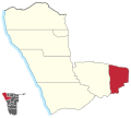
Khorixas Constituency (category Constituencies of Kunene Region)
question marks, boxes, or other symbols. Khorixas is a constituency in the Kunene Region of northwestern Namibia. Its district capital is the town of Khorixas...
3 KB (282 words) - 09:12, 2 April 2024

Epupa Constituency (category Constituencies of Kunene Region)
Constituency (until 1998: Ruacana Constituency) is a constituency in the Kunene Region of Namibia. The constituency contains the Epupa Falls after which it...
5 KB (463 words) - 12:28, 31 March 2024

Opuwo Constituency (category Constituencies of Kunene Region)
Opuwo was a constituency in the Kunene Region of Namibia. Its population in 2010 was 20,119, and its administrative capital was Opuwo. Opuwo Constituency...
3 KB (212 words) - 13:13, 2 April 2024

respective regional administration. Some of the settlements in Namibia per Region are: Fransfontein Ohamaremba, Epupa Constituency Okangwati, Epupa Constituency...
24 KB (1,321 words) - 17:40, 21 July 2024

River on the border of Angola and Namibia, in the Kaokoland area of the Kunene Region. The river is about 0.5 kilometres (1,600 ft) wide in this area and...
4 KB (496 words) - 23:04, 28 July 2024
Okonjima (category Populated places in the Kunene Region)
Okonjima (Herero: place of the baboons) is a nature reserve located 50 km (31 mi) from Otjiwarongo in the Omboroko Mountains of Namibia. Okonjima Nature...
1 KB (64 words) - 18:26, 5 June 2024

"wife-sharing" among the nomadic OvaHimba and OvaZemba peoples of Namibia's Kunene and Omusati regions. According to the practice, a man welcomes a familiar...
7 KB (624 words) - 20:42, 28 May 2024

with Cerussite, Christoff Mine, Kunene Region, Namibia. 6.9 × 5.7 × 4.8 cm Dioptase on Chrysocolla, Otjikotu, Kunene Region, Namibia. 6.8 × 5.5 × 4.5 cm...
10 KB (988 words) - 13:11, 25 July 2024

Kaokoland (category Kunene Region)
area, while the political unit of administration since 1990 has been Kunene Region. The area is in the Kaokoveld ecoregion. The area is one of the wildest...
10 KB (1,156 words) - 08:11, 30 March 2024

Opuwo (category Populated places in the Kunene Region)
Opuwo is the capital of the Kunene Region in north-western Namibia. The town is situated about 720 km north-northwest of the capital Windhoek, and has...
14 KB (817 words) - 22:18, 25 June 2024

Cunene Province (redirect from Kunene Province)
find the CIA remnants under Woods held by the MPLA and the Cubans. Kunene Region in Namibia "Resultados Definitivos Recenseamento Geral da População...
9 KB (504 words) - 00:26, 29 May 2024

Outjo (category Populated places in the Kunene Region)
Outjo (Otjiherero: small hills) is a town of 15,000 inhabitants in the Kunene Region of Namibia. It is the district capital of Outjo Constituency. It is...
11 KB (750 words) - 19:37, 16 March 2024

(Damara/Nama: jumping waterhole), is a site of ancient rock engravings in the Kunene Region of north-western Namibia. It consists of a spring in a valley flanked...
25 KB (2,037 words) - 21:26, 14 July 2023

Burnt Mountain (Namibia) (category Geography of Kunene Region)
The Burnt Mountain (Afrikaans: Verbrande Berg) is a hill with a solidified lava flow at the foot of a 12-kilometre-long volcanic ridge in Damaraland in...
3 KB (152 words) - 15:06, 29 July 2024

Vipuakuje Muharukua (category People from Kunene Region)
2002. Muharukua, an ethnic Ovahimba, was born in 1983 in Opuwo in the Kunene Region of north-western Namibia. He was elected to the parliament of Namibia...
3 KB (266 words) - 21:20, 17 May 2024

Organ Pipes (Namibia) (category Geography of Kunene Region)
Pipes are a well-known landmark and popular tourist attraction in the Kunene Region. Organ Pipes and Burnt Mountain at www.myguidenamibia.com. Retrieved...
1 KB (132 words) - 22:07, 27 January 2024

2022, 46 of which were killed in Etosha. The park is located in the Kunene region[citation needed] and shares boundaries with the regions of Oshana, Oshikoto...
25 KB (2,167 words) - 13:22, 9 August 2024

several northern regions: Oshana Region, Kavango East Region, Omusati Region, Zambezi Region, Omaheke Region, Kunene Region, and parts of the Khomas and Oshikoto...
9 KB (970 words) - 23:58, 29 December 2023
Primary School, Anker, Kunene Region Ebenhaeser Primary School, Karibib, Erongo Region Eddie Bowe Primary School, Khorixas, Kunene Region Edundja Junior Secondary...
54 KB (4,515 words) - 07:30, 5 August 2024

threatened by poaching and from changes in land use by humans. The Kunene Region in the northwest of Namibia is an area of mostly sandy desert, rocky...
10 KB (1,221 words) - 12:29, 9 May 2024