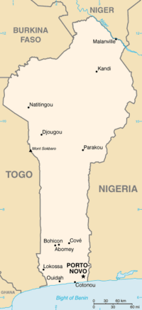
Malanville [ma.lɑ̃.vil] is a city, arrondissement and commune in the Alibori Department of northeastern Benin, located across the River Niger from Niger...
7 KB (422 words) - 04:00, 24 June 2024
Its centers today are the cities of Gaya in Niger, Kamba in Nigeria and Malanville in Benin. Under the Songhai empire, Dendi had been the easternmost province...
8 KB (865 words) - 13:44, 28 July 2024

Niamey, Gao, Tillaberi, Dosso, Parakou, Kandi, Natitingou, Djougou, Malanville, Gorom-Gorom, In-Gall and Tabelbala . They have been widely used as a...
20 KB (1,848 words) - 23:02, 20 July 2024
Kpanroun Kpomasse Kpome Lalo Libante Liboussou Lokossa Lon-Agonmey Lougba Malanville Manta Materi Monsey Natitingou Ndali Nikki Oroukayo Ouake Ouedo Ouenou...
4 KB (247 words) - 17:07, 19 July 2024

capital; other major settlements include Banikoara, Gounarou, Guénè, Malanville and Ségbana. According to Benin's 2013 census, the total population of...
10 KB (916 words) - 03:52, 24 June 2024

Benin. Pékinga Compa Karimama Malanville Mandécali Koulou Sia Tenda Tara Gaya The main border crossing is located at Malanville (Benin)-Gaya (Niger). It is...
6 KB (672 words) - 11:17, 4 February 2022
sassaby. The peripheral municipalities of Banikoara, Kandi, Karimama and Malanville had to cede lands to the biosphere reserve. CENAGREF works with the Italian...
3 KB (226 words) - 03:24, 1 April 2024
communes are listed below, by department: Banikoara Gogounou Kandi Karimama Malanville Segbana Boukoumbé Cobly Kérou Kouandé Matéri Natitingou Pehonko Tanguiéta...
4 KB (164 words) - 03:11, 15 July 2024

1970 1,153.9 36 Middle Niger Gaya 1,120 156 1,404,600 1929 1,086.7 34 Malanville 1,130 157 1,399,238 1929 1,086.7 34 Niamey 1,420 176 791,121 1929 893...
49 KB (3,394 words) - 01:48, 10 July 2024
Arrondissements of Benin (section Malanville)
Sonsoro Birni-Lafia, Bogo-Bogo, Karimama, Kompa, Monsey Garou, Guénè, Malanville, Mandécali, Tomboutou Libantè, Liboussou, Lougou, Ségbana, Sokotindji...
12 KB (706 words) - 18:51, 1 May 2022
Kandi, Gogounou, Ségbana 63 XXXX 23 63 XXXX Banikoara 65 XXXX 23 65 XXXX Malanville 67 XXXX 23 67 XXXX Djougou 80 XXXX 23 80 XXXX Natitingou 82 XXXX 23 82...
4 KB (105 words) - 16:36, 9 June 2024
Garoua-Boulaï/ Cantonnier Cameroon / Central African Republic Gaya/Malanville Niger / Benin Gbiti/Banga-Boumbé Cameroon / Central African Republic...
53 KB (129 words) - 01:56, 7 August 2024
Hopkins – Frederick Charles Hopkins Victoria Peak (Belize) – Queen Victoria Malanville – Henri Malan, French Governor of Dahomey Hamilton – Henry Hamilton Jigme...
295 KB (31,707 words) - 02:52, 3 August 2024

the Marché Guema, located next to Guema Church on the northern road to Malanville in the Albarika quarter of the city. The market was founded by the Somba...
16 KB (1,123 words) - 03:58, 13 July 2024
is an administrative division under the jurisdiction of the commune of Malanville. According to the population census conducted by the Institut National...
3 KB (74 words) - 16:15, 17 December 2022
runs toward the north-north-east and empties into the Niger River at Malanville. The annual precipitation has been recorded at several stations in the...
5 KB (457 words) - 13:38, 1 June 2024

market, located in Cotonou, is the largest open-air market in West Africa. Malanville Grain Market: This market functions twice a week and is located on the...
8 KB (1,199 words) - 17:58, 2 May 2020
north-west. With the exception of the road linking Cotonou in the south to Malanville on the border with Niger in the north, and from Parakou in central Benin...
7 KB (734 words) - 02:46, 15 June 2024
Kroonstad Station General information Location Stasie Street, Charl Malanville, Kroonstad, 9501 Coordinates 27°39′35″S 27°14′02″E / 27.6596°S 27.2339°E...
1,022 bytes (20 words) - 11:59, 20 July 2023

in rainfall a year. There is a bridge connecting Gaya to the town of Malanville in Benin. Gaya is located in the south-west of the country on the Niger...
11 KB (865 words) - 12:42, 22 May 2024

in the Sudanian savanna zone. Communally it is bounded to the north by Malanville, south by Gogounou, west by Banikoara and to the east by Ségbana. Kandi...
13 KB (678 words) - 03:59, 24 June 2024
N'Dali and flows north-north-east until it reaches the Niger River at Malanville. It is also the seat of the Roman Catholic Diocese of N’Dali. "Ndali"...
5 KB (194 words) - 17:18, 24 June 2024

is an administrative division under the jurisdiction of the commune of Malanville. According to the population census conducted by the Institut National...
3 KB (68 words) - 06:33, 14 March 2023
Cotonou get placed on trucks first heading north to the border towns of Malanville in Benin and Gaya in Niger and then onto the rest of the Sahel. Parakou...
8 KB (1,069 words) - 09:00, 13 October 2023
2016 survey conducted in the cities of Cotonou in southern Benin and Malanville in northern Benin indicated that girls are subjected to sexual exploitation...
9 KB (968 words) - 14:05, 3 July 2024
Ganvie Gogounou Grand Popo Kandi Karimama Kouandé Kérou Kétou Lokossa Malanville Natitingou Ndali (Benin) Nikki, Benin Ouidah Parakou Pobé Porga Porto-Novo...
23 KB (1,829 words) - 17:46, 28 January 2024
River. Communally it is bounded to the north and east by Niger, south by Malanville and to the west by Banikoara. Karimana is subdivided into 5 arrondissements;...
6 KB (221 words) - 03:59, 24 June 2024
Department Lokossa Gabriel Lozès Madiatom Hubert Maga Mahu Abou Maiga Malanville Chabi Mama Manafaga Manala, Benin Manigri Matéri Mborko Mekrou River Military...
18 KB (1,827 words) - 22:06, 7 February 2023

Benin Parakou (438 km) - railhead in north Ndali Kandi Guéné Lama-Kara Malanville border (574 km) near Niger River bridge. Gaya (1,435 mm (4 ft 8+1⁄2 in)...
7 KB (455 words) - 14:56, 7 September 2023

Cotonou get placed on trucks first heading north to the border towns of Malanville in Benin and Gaya in Niger and then onto the rest of the Sahel. Parakou...
51 KB (7,283 words) - 20:33, 28 July 2024