
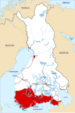
en:Image:FinnishCivilWarMapEnd.jpg. Base map of Finland: Image:Finland 1918 plain.png. Author Original map of the War: Ville Virrankoski. Base map of Finland in...
(611 × 914 (461 KB)) - 16:25, 20 December 2023

Фінляндыі 1918 года (канец вайны, нямецкае наступленне) Date 20 December 2023 Source Based on Image:FinnishCivilWarMapEnd.svg. Author A potato hater...
(611 × 914 (359 KB)) - 05:55, 13 March 2024

DescriptionFinnishCivilWarMapEnd-hu.svg Magyar: A finn polgárháború végi hadmozdulatok, zölddel a német interenció Date 1 September 2018 Source Own work...
(611 × 914 (526 KB)) - 00:51, 1 June 2022

This file has been superseded by FinnishCivilWarMapEnd.svg. It is recommended to use the other file. Please note that deleting superseded images requires...
(809 × 497 (46 KB)) - 16:51, 20 July 2024
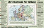
File:A Tapestry of Chaos - Europe in 1919.pdf (category PDF that should be converted to SVG)
BY-SA 4.0 Creative Commons Attribution-Share Alike 4.0 truetrue English Map of Post WWI Europe with regional disputes noted URL: https://commons.wikimedia...
(2,550 × 1,650 (1.3 MB)) - 11:33, 26 August 2024
DescriptionFinnishCivilWarMapBegin.svg English: Initial front lines and offensives of the Civil War at the beginning of February, 1918. Area controlled...
(611 × 914 (459 KB)) - 16:39, 17 December 2023

DescriptionFinnishCivilWarMapMiddle.svg English: The main offensives on the end of March 1918 in the Finnish Civil War. Date 24 March 2007 Source Based...
(611 × 914 (458 KB)) - 16:25, 20 December 2023