
 French
 Deutsch
ملف:Pakistan-Waziristan-Map.png - ويكيبيديا

حجم هذه المعاينة: 606 × 599 بكسل. الأبعاد الأخرى: 243 × 240 بكسل | 486 × 480 بكسل | 700 × 692 بكسل.
الملف الأصلي (700 × 692 بكسل حجم الملف: 96 كيلوبايت، نوع MIME: image/png)
| هذا ملف من ويكيميديا كومنز. معلومات من صفحة وصفه مبينة في الأسفل. كومنز مستودع ملفات ميديا ذو رخصة حرة. |
ملخص
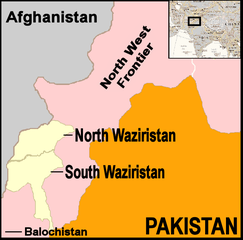
| الوصف | English: Map showing location of North and South Waziristan in northern Pakistan and bordering on Afghanistan | ||||
| التاريخ | |||||
| المصدر | drawn by uploader using Jasc Paint Shop, using as insert map a reference map in Public Domain from the United States Central Intelligence Agency | ||||
| المؤلف | Thaddeus P. Bejnar | ||||
| الترخيص (إعادة استخدام هذا الملف) | Public Domain, I (Thaddeus P. Bejnar) hereby release this work to the Public Domain | ||||
| إصدارات أخرى |
Note: Comments "areas of activity" means that this is not territorial control is shown.
|


.svg)


.svg)


.svg)


_Territory_Change_2014-2016.gif)

_(within_Northern_Syria).svg)


.png)
.svg)


_map.png)
.svg)


.svg)


ترخيص
| أنا، مالِك حقوق تأليف ونشر هذا العمل، أجعله في النِّطاق العامِّ، يسري هذا في أرجاء العالم كلِّه. في بعض البلدان، قد يكون هذا التَّرخيص غيرَ مُمكنٍ قانونيَّاً، في هذه الحالة: أمنح الجميع حق استخدام هذا العمل لأي غرض دون أي شرط ما لم يفرض القانون شروطًا إضافية. |
تاريخ الملف
اضغط على زمن/تاريخ لرؤية الملف كما بدا في هذا الزمن.
| زمن/تاريخ | صورة مصغرة | الأبعاد | مستخدم | تعليق | |
|---|---|---|---|---|---|
| حالي | 21:59، 7 نوفمبر 2006 | | 700 × 692 (96 كيلوبايت) | Bejnar | {{Information |Description=Map showing location of North and South Waziristan in northern Pakistan and bordering on Afghanistan |Source=drawn by uploader using Jasc Paint Shop |Date=7 November 2006 |Author=Thaddeus P. Bejnar |Permission=Public Domain, I ( |
استخدام الملف
الصفحة التالية تستخدم هذا الملف:
الاستخدام العالمي للملف
الويكيات الأخرى التالية تستخدم هذا الملف:
- الاستخدام في ca.wikipedia.org
- الاستخدام في cs.wikipedia.org
- الاستخدام في cy.wikipedia.org
- الاستخدام في de.wikinews.org
- الاستخدام في en.wikinews.org
- 17 troops killed in bombing on Afghanistan-Pakistan border; Separate bombing kills dozens of civilians
- High level al-Qaeda leader reported dead
- Pakistani military launches ground offensive against Taliban and al-Qaeda
- Pakistan: Twelve militants killed in recent fighting
- Suspected US drone attack kills at least fourteen in Pakistan
- الاستخدام في fr.wikipedia.org
- الاستخدام في it.wikipedia.org
- الاستخدام في nl.wikipedia.org
- الاستخدام في pt.wikipedia.org
- الاستخدام في pt.wikinews.org