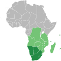
ملف:Southern African Development Community.svg - ويكيبيديا

حجم معاينة PNG لذلك الملف ذي الامتداد SVG: 600 × 600 بكسل. الأبعاد الأخرى: 240 × 240 بكسل | 480 × 480 بكسل | 768 × 768 بكسل | 1٬024 × 1٬024 بكسل | 2٬048 × 2٬048 بكسل | 1٬000 × 1٬000 بكسل.
الملف الأصلي (ملف SVG، أبعاده 1٬000 × 1٬000 بكسل، حجم الملف: 184 كيلوبايت)
تاريخ الملف
اضغط على زمن/تاريخ لرؤية الملف كما بدا في هذا الزمن.
| زمن/تاريخ | صورة مصغرة | الأبعاد | مستخدم | تعليق | |
|---|---|---|---|---|---|
| حالي | 10:34، 23 يوليو 2018 |  | 1٬000 × 1٬000 (184 كيلوبايت) | Ydecreux | Added Comoros |
| 11:59، 21 نوفمبر 2011 |  | 1٬000 × 1٬000 (184 كيلوبايت) | Htonl | color scheme | |
| 13:20، 20 نوفمبر 2011 |  | 1٬000 × 1٬000 (184 كيلوبايت) | Htonl | == {{int:filedesc}} == {{Information |Description=Map of Africa showing the member nations of the w:Southern African Development Community (SADC). Nations that are members of SADC and the w:Southern African Customs Union (SACU) are coloured dark |
استخدام الملف
الصفحة التالية تستخدم هذا الملف:
الاستخدام العالمي للملف
الويكيات الأخرى التالية تستخدم هذا الملف:
- الاستخدام في af.wikipedia.org
- الاستخدام في ast.wikipedia.org
- الاستخدام في bg.wikipedia.org
- الاستخدام في ca.wikipedia.org
- الاستخدام في cs.wikipedia.org
- الاستخدام في en.wikipedia.org
- الاستخدام في es.wikipedia.org
- الاستخدام في et.wikipedia.org
- الاستخدام في eu.wikipedia.org
- الاستخدام في fa.wikipedia.org
- الاستخدام في fr.wikipedia.org
- الاستخدام في ha.wikipedia.org
- الاستخدام في hr.wikipedia.org
- الاستخدام في id.wikipedia.org
- الاستخدام في it.wikipedia.org
- الاستخدام في ko.wikipedia.org
- الاستخدام في mg.wikipedia.org
- الاستخدام في pl.wikipedia.org
- الاستخدام في pnb.wikipedia.org
- الاستخدام في pt.wikipedia.org
- الاستخدام في ru.wikipedia.org
- الاستخدام في sr.wikipedia.org
- الاستخدام في sw.wikipedia.org
- الاستخدام في tn.wikipedia.org
- الاستخدام في vi.wikipedia.org
- الاستخدام في www.wikidata.org
- الاستخدام في zh.wikipedia.org


 French
 Deutsch