
 French
 Deutsch
Datei:Arunachal Pradesh in India.png – Wikipedia
Arunachal_Pradesh_in_India.png (350 × 425 Pixel, Dateigröße: 80 KB, MIME-Typ: image/png)
![]()
Diese Datei und die Informationen unter dem roten Trennstrich werden aus dem zentralen Medienarchiv Wikimedia Commons eingebunden.
![]()
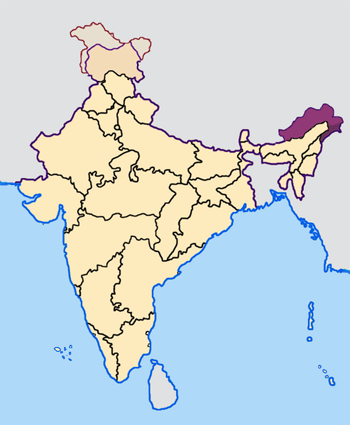
Map made by me, Nichalp
Note: The Indian state of w:Arunachal Pradesh is claimed by China as a part of w:South Tibet. The claimed region is shown in a different colour.
The Indian state of w:Jammu and Kashmir is claimed by w:India, w:Pakistan and the w:People's Republic of China. This map depicts the boundaries of the state as it was in 1947. Areas administered by India is coloured as per the rest of the states, and the area administered by Pakistan and China are coloured in a neutral colour. See the map of Jammu and Kashmir.
See the map of Arunachal Pradesh.
The Indian territorial waters extend to a distance of twelve nautical miles.
 | Es ist erlaubt, die Datei unter den Bedingungen der GNU-Lizenz für freie Dokumentation, Version 1.2 oder einer späteren Version, veröffentlicht von der Free Software Foundation, zu kopieren, zu verbreiten und/oder zu modifizieren; es gibt keine unveränderlichen Abschnitte, keinen vorderen und keinen hinteren Umschlagtext. Der vollständige Text der Lizenz ist im Kapitel GNU-Lizenz für freie Dokumentation verfügbar. |
| Diese Datei ist unter der Creative-Commons-Lizenz „Namensnennung – Weitergabe unter gleichen Bedingungen 3.0 nicht portiert“ lizenziert. | ||
| ||
| Diese Lizenzmarkierung wurde auf Grund der GFDL-Lizenzaktualisierung hinzugefügt. |
Dateiversionen
Klicke auf einen Zeitpunkt, um diese Version zu laden.
| Version vom | Vorschaubild | Maße | Benutzer | Kommentar | |
|---|---|---|---|---|---|
| aktuell | 09:27, 23. Apr. 2005 | | 350 × 425 (80 KB) | Nichalp | NPOV map |
| 09:21, 23. Apr. 2005 |  | 200 × 231 (22 KB) | Kerpal | Reverted to earlier revision | |
| 08:13, 23. Apr. 2005 |  | 650 × 790 (126 KB) | Nichalp | Reverted to earlier revision | |
| 06:59, 23. Apr. 2005 |  | 200 × 231 (22 KB) | Kerpal | Reverted to earlier revision | |
| 06:50, 23. Apr. 2005 |  | 650 × 790 (126 KB) | Nichalp | Reverted to earlier revision | |
| 23:04, 22. Apr. 2005 |  | 200 × 231 (22 KB) | Kerpal | Reverted to earlier revision | |
| 15:32, 22. Apr. 2005 |  | 650 × 790 (126 KB) | Nichalp | Reverted to earlier revision | |
| 11:55, 22. Apr. 2005 |  | 200 × 231 (22 KB) | Kerpal | originally by en:User:Morwen | |
| 19:47, 21. Apr. 2005 |  | 650 × 790 (126 KB) | Nichalp | Map made by me, ~~~ Note: The Indian state of w:Jammu and Kashmir is claimed by w:India, w:Pakistan and the [w:People's Republic of China]]. This map depicts the boundaries of the state as it was in 1947. Areas administered by India is colou |
Dateiverwendung
Die folgende Seite verwendet diese Datei:
Globale Dateiverwendung
Die nachfolgenden anderen Wikis verwenden diese Datei:
- Verwendung auf bxr.wikipedia.org
- Verwendung auf en.wikipedia.org
- Verwendung auf fi.wikipedia.org
- Verwendung auf incubator.wikimedia.org
- Verwendung auf ka.wikipedia.org
- Verwendung auf mr.wikipedia.org
- Verwendung auf ta.wikipedia.org
- Verwendung auf te.wikipedia.org
- Verwendung auf xmf.wikipedia.org