
 French
 Deutsch
Datei:Wizernes site local map.jpg – Wikipedia

Größe dieser Vorschau: 621 × 600 Pixel. Weitere Auflösungen: 249 × 240 Pixel | 497 × 480 Pixel | 795 × 768 Pixel | 1.071 × 1.034 Pixel
Originaldatei (1.071 × 1.034 Pixel, Dateigröße: 550 KB, MIME-Typ: image/jpeg)
![]()
Diese Datei und die Informationen unter dem roten Trennstrich werden aus dem zentralen Medienarchiv Wikimedia Commons eingebunden.
![]()
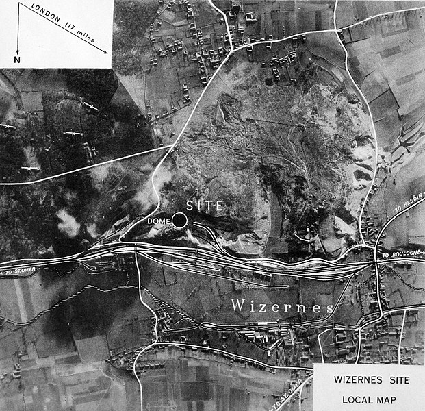
| Beschreibung | English: Wizernes site: map of the area | |||
| Datum | ||||
| Quelle | Investigation of the "Heavy" Crossbow installations in Northern France. Report by the Sanders Mission to the Chairman of the Crossbow Committee. Technical details; Vol III, "Wizernes" | |||
| Urheber | Sanders, T.R.B. | |||
| Genehmigung (Weiternutzung dieser Datei) |
|

Dateiversionen
Klicke auf einen Zeitpunkt, um diese Version zu laden.
| Version vom | Vorschaubild | Maße | Benutzer | Kommentar | |
|---|---|---|---|---|---|
| aktuell | 02:15, 16. Jun. 2011 | | 1.071 × 1.034 (550 KB) | Prioryman | {{Information |Description ={{en|1=Wizernes site: map of the area}} |Source =Investigation of the "Heavy" Crossbow installations in Northern France. Report by the Sanders Mission to the Chairman of the Crossbow Committee. Technical details; Vol |
Dateiverwendung
Die folgende Seite verwendet diese Datei:
Globale Dateiverwendung
Die nachfolgenden anderen Wikis verwenden diese Datei:
- Verwendung auf en.wikipedia.org
- Verwendung auf es.wikipedia.org
- Verwendung auf fr.wikipedia.org