Ōrākei Local Board
This article needs additional citations for verification. (December 2015) |
Ōrākei Local Board Te Poari ā-Rohe o Ōrākei | |
|---|---|
 Ōrākei Local Board office in Meadowbank | |
 | |
| Country | New Zealand |
| Region | Auckland |
| Territorial authority | Auckland Council |
| Ward | Ōrākei ward |
| Legislated | 2010 |
| Area | |
| • Land | 32.39 km2 (12.51 sq mi) |
| Population (June 2024)[2] | |
• Total | 87,400 |
Local Board Members | |
|---|---|
| Leadership | |
Chairperson | |
Deputy chairperson | Sarah Powrie, C & R |
| Structure | |
| Seats | 7 |
Political groups | Communities and Residents (7) |
Length of term | 3 years |
| Elections | |
Last election | 2022 |
Next election | 2025 |
| Meeting place | |
| 25 St Johns Road, Meadowbank | |
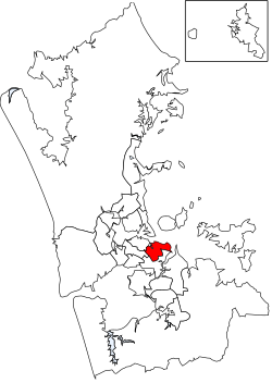
The Ōrākei Local Board is one of the 21 local boards of Auckland Council. It is coterminous with the Ōrākei ward. It was chaired in its first two terms by local politician Desley Simpson following the 2010 and 2013 elections. In the 2016 elections, Simpson stood for and won the Orakei ward councillor seat on Auckland Council. Colin Davis took her place as Chair.
Governance
[edit]The board consists of 7 members who were elected in the 2022 local elections.
Demographics
[edit]Ōrākei Local Board Area covers 32.39 km2 (12.51 sq mi)[1] and had an estimated population of 87,400 as of June 2024,[2] with a population density of 2,698 people per km2.
| Year | Pop. | ±% p.a. |
|---|---|---|
| 2006 | 74,520 | — |
| 2013 | 79,539 | +0.94% |
| 2018 | 84,318 | +1.17% |
| 2023 | 83,196 | −0.27% |
| Source: [3][4] | ||
Ōrākei Local Board Area had a population of 83,196 in the 2023 New Zealand census, a decrease of 1,122 people (−1.3%) since the 2018 census, and an increase of 3,657 people (4.6%) since the 2013 census. There were 39,921 males, 42,996 females and 279 people of other genders in 30,573 dwellings.[5] 3.4% of people identified as LGBTIQ+. The median age was 40.9 years (compared with 38.1 years nationally). There were 14,520 people (17.5%) aged under 15 years, 15,543 (18.7%) aged 15 to 29, 38,577 (46.4%) aged 30 to 64, and 14,553 (17.5%) aged 65 or older.[4]
People could identify as more than one ethnicity. The results were 68.4% European (Pākehā); 6.4% Māori; 3.7% Pasifika; 26.7% Asian; 3.4% Middle Eastern, Latin American and African New Zealanders (MELAA); and 1.8% other, which includes people giving their ethnicity as "New Zealander". English was spoken by 95.4%, Māori language by 1.4%, Samoan by 0.5%, and other languages by 27.4%. No language could be spoken by 1.6% (e.g. too young to talk). New Zealand Sign Language was known by 0.3%. The percentage of people born overseas was 39.9, compared with 28.8% nationally.[4]
Religious affiliations were 35.3% Christian, 2.4% Hindu, 1.4% Islam, 0.4% Māori religious beliefs, 2.1% Buddhist, 0.2% New Age, 0.7% Jewish, and 1.3% other religions. People who answered that they had no religion were 50.8%, and 5.6% of people did not answer the census question.[4]
Of those at least 15 years old, 33,750 (49.1%) people had a bachelor's or higher degree, 24,357 (35.5%) had a post-high school certificate or diploma, and 10,563 (15.4%) people exclusively held high school qualifications. The median income was $58,000, compared with $41,500 nationally. 18,786 people (27.4%) earned over $100,000 compared to 12.1% nationally. The employment status of those at least 15 was that 36,624 (53.3%) people were employed full-time, 9,627 (14.0%) were part-time, and 1,443 (2.1%) were unemployed.[4]
2022 local elections
[edit]Between September and October 2022, the 2022 Auckland local elections took place. The board members elected for the 2022-2025 term were:[6]
- Troy Churton, C&R - Communities & Residents (18,961 votes)
- David Wong, C&R - Communities & Residents (18,488 votes)
- Scott Milne, C&R - Communities & Residents (18,422 votes)
- Penny Tucker, C&R - Communities & Residents (18,251 votes)
- Sarah Powrie, C&R - Communities & Residents (17,501 votes)
- Margaret Voyce, C&R - Communities & Residents (16,352 votes)
- Angus Mcphee, C&R - Communities & Residents (16,119 votes)
References
[edit]- ^ a b "Stats NZ Geographic Data Service". Community Board 2023 (generalised). Retrieved 21 February 2025.
- ^ a b "Aotearoa Data Explorer". Statistics New Zealand. Retrieved 26 October 2024.
- ^ "Statistical area 1 dataset for 2018 Census". Statistics New Zealand. March 2020. Ōrākei Ward (07608).
- ^ a b c d e "Totals by topic for individuals, (RC, TALB, UR, SA3, SA2, Ward, Health), 2013, 2018, and 2023 Censuses". Stats NZ – Tatauranga Aotearoa – Aotearoa Data Explorer. Ōrākei Local Board Area (07614). Retrieved 3 October 2024.
- ^ "Totals by topic for dwellings, (RC, TALB, UR, SA3, SA2, Ward, Health), 2013, 2018, and 2023 Censuses". Stats NZ – Tatauranga Aotearoa – Aotearoa Data Explorer. Retrieved 3 October 2024.
- ^ "Ōrākei Local Board – confirmed". Auckland Council. Retrieved 4 April 2023.


 French
 Deutsch