Alto Parnaíba
Alto Parnaíba | |
|---|---|
municipality | |
 Cachoeira das Tabocas | |
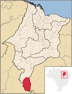
 Location of Alto Parnaíba | |
| Coordinates: 09°06′39″S 45°55′48″W / 9.11083°S 45.93000°W | |
| Country | Brazil |
| Region | Northeast |
| State | Maranhão |
| Founded | May 19, 1866 |
| Government | |
| • Mayor | Ranieri Avelino Soares |
| Area | |
• Total | 11,132.105 km2 (4,298.130 sq mi) |
| Population (2020 [1]) | |
• Total | 11,212 |
| • Density | 0.9/km2 (2/sq mi) |
| Time zone | UTC−3 (BRT) |
| HDI (2000) | 0.636 – medium[2] |
Alto Parnaíba is a Brazilian municipality in the southernmost tip of the state of Maranhão. In 2020, the city's population was 11,212.
The municipality contains part of the 724,324 hectares (1,789,840 acres) Nascentes do Rio Parnaíba National Park, created in 2002.[3]
Climate
[edit]Alto Parnaíba experiences a tropical savanna climate (Köppen: Aw) with hot temperatures and distinct wet and dry seasons.
The city experiences a wet season from November to April. The dry season extends from May to September, with June through August having almost no rainfall.[4]
Alto Parnaíba has hot and humid conditions throughout the year. September and October, before the wet season, are the hottest months, with average highs around 36 °C (97 °F).[4]
| Climate data for Alto Parnaíba (1991–2020) | |||||||||||||
|---|---|---|---|---|---|---|---|---|---|---|---|---|---|
| Month | Jan | Feb | Mar | Apr | May | Jun | Jul | Aug | Sep | Oct | Nov | Dec | Year |
| Mean daily maximum °C (°F) | 32.0 (89.6) | 32.0 (89.6) | 32.2 (90.0) | 32.7 (90.9) | 33.2 (91.8) | 33.3 (91.9) | 33.8 (92.8) | 35.3 (95.5) | 36.7 (98.1) | 35.8 (96.4) | 33.5 (92.3) | 32.4 (90.3) | 33.6 (92.5) |
| Daily mean °C (°F) | 26.0 (78.8) | 25.9 (78.6) | 26.1 (79.0) | 26.3 (79.3) | 26.1 (79.0) | 25.0 (77.0) | 24.7 (76.5) | 25.8 (78.4) | 27.9 (82.2) | 28.3 (82.9) | 27.1 (80.8) | 26.4 (79.5) | 26.3 (79.3) |
| Mean daily minimum °C (°F) | 21.9 (71.4) | 21.9 (71.4) | 22.0 (71.6) | 21.8 (71.2) | 20.7 (69.3) | 18.2 (64.8) | 17.0 (62.6) | 17.5 (63.5) | 20.2 (68.4) | 22.3 (72.1) | 22.4 (72.3) | 22.1 (71.8) | 20.7 (69.3) |
| Average precipitation mm (inches) | 231.0 (9.09) | 195.7 (7.70) | 241.6 (9.51) | 128.4 (5.06) | 39.6 (1.56) | 2.5 (0.10) | 0.4 (0.02) | 2.0 (0.08) | 14.1 (0.56) | 74.8 (2.94) | 163.8 (6.45) | 186.3 (7.33) | 1,280.2 (50.40) |
| Average precipitation days (≥ 1.0 mm) | 16.3 | 15.4 | 15.9 | 10.9 | 4.0 | 0.4 | 0.1 | 0.3 | 1.8 | 6.7 | 11.5 | 13.5 | 96.8 |
| Average relative humidity (%) | 81.0 | 82.2 | 82.5 | 79.5 | 74.2 | 68.3 | 63.4 | 58.3 | 56.7 | 64.4 | 75.2 | 78.6 | 72.0 |
| Average dew point °C (°F) | 22.8 (73.0) | 22.9 (73.2) | 23.1 (73.6) | 22.9 (73.2) | 21.9 (71.4) | 19.9 (67.8) | 18.4 (65.1) | 18.1 (64.6) | 19.2 (66.6) | 21.2 (70.2) | 22.5 (72.5) | 22.7 (72.9) | 21.3 (70.3) |
| Mean monthly sunshine hours | 165.4 | 142.5 | 165.7 | 189.4 | 240.5 | 274.8 | 298.2 | 288.6 | 252.9 | 222.2 | 173.8 | 163.0 | 2,577 |
| Source: NOAA[4] | |||||||||||||
References
[edit]- ^ IBGE 2020
- ^ "Archived copy". Archived from the original on 2009-10-03. Retrieved 2009-12-17.
{{cite web}}: CS1 maint: archived copy as title (link) - UNDP - ^ Unidade de Conservação: Parque Nacional das Nascentes do Rio Parnaíba (in Portuguese), MMA: Ministério do Meio Ambiente, retrieved 2016-05-01
- ^ a b c "World Meteorological Organization Climate Normals for 1991-2020 — Alto Parnaíba". National Oceanic and Atmospheric Administration. Retrieved January 29, 2024.


 French
 Deutsch

