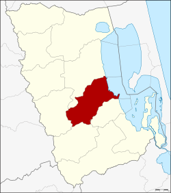
Khao Chaison district
Khao Chaison เขาชัยสน | |
|---|---|
 Wat Khian Bang Kaeo Temple | |
 District location in Phatthalung province | |
| Coordinates: 7°27′42″N 100°8′0″E / 7.46167°N 100.13333°E | |
| Country | Thailand |
| Province | Phatthalung |
| Seat | Khao Chaison |
| Area | |
• Total | 260.1 km2 (100.4 sq mi) |
| Population (2005) | |
• Total | 43,292 |
| • Density | 166.4/km2 (431/sq mi) |
| Time zone | UTC+7 (ICT) |
| Postal code | 93130 |
| Geocode | 9303 |
Khao Chaison (Thai: เขาชัยสน, pronounced [kʰǎw t͡ɕʰāj.sǒn]) is a district (amphoe) of Phatthalung province, southern Thailand.
Geography
[edit]Neighboring districts are (from the south clockwise) Bang Kaeo, Tamot, Kong Ra, and Mueang Phatthalung of Phatthalung Province, Krasae Sin of Songkhla province.
The east of the district is on the shore of Thale Luang lake.
History
[edit]The district dates back to the minor district (king amphoe) Lampam (ลำปำ), created in 1923 as a subordinate of Mueang Phatthalung District. It consisted of the two sub-districts Lampam and Han Po.[1] On 1 November 1939, the sub-districts Lampam, Phaya Khan, and Khuan Maphrao were reassigned to Mueang District, while the sub-districts Khao Chaison and Khuan Khanun from Mueang District as well as Tha Duea and Chong Thanon from Pak Phayun were added to the minor district.[2] The district office was then moved into Khao Chaison sub-district.[3] In 1940, the minor district was then renamed Khao Chaison to match the central tambon.[4] It was upgraded to a full district on 1 January 1953.[5]
Administration
[edit]The district is divided into five sub-districts (tambons), which are further subdivided into 56 villages (mubans). Khao Chaison is a township (thesaban tambon) which covers parts of tambon Khao Chaison. There are a further five tambon administrative organizations (TAO).
| No. | Name | Thai name | Villages | Pop. | |
|---|---|---|---|---|---|
| 1. | Khao Chaison | เขาชัยสน | 14 | 12,637 | |
| 2. | Khuan Khanun | ควนขนุน | 10 | 8,571 | |
| 5. | Chong Thanon | จองถนน | 7 | 3,681 | |
| 6. | Han Pho | หานโพธิ์ | 11 | 8,704 | |
| 7. | Khok Muang | โคกม่วง | 14 | 9,699 |
Missing numbers are tambon which now form Bang Kaeo District.
References
[edit]- ^ "ข้อมูลอำเภอเชาชัยสน อำเภอ Pattalung.com". Archived from the original on 2007-12-07. Retrieved 2007-11-14.
- ^ ประกาศกระทรวงมหาดไทย เรื่อง เปลี่ยนแปลงเขตอำเภอและกิ่งอำเภอ จังหวัดพัทลุง (PDF). Royal Gazette (in Thai). 56 (ง): 2379–2380. November 6, 1939. Archived from the original (PDF) on May 10, 2012.
- ^ ประกาศกระทรวงมหาดไทย เรื่อง ย้ายที่ว่าการกิ่งอำเภอลำป่า จังหวัดพัทลุง (PDF). Royal Gazette (in Thai). 56 (ง): 2378–2379. November 6, 1939. Archived from the original (PDF) on May 10, 2012.
- ^ พระราชกฤษฎีกาเปลี่ยนนามอำเภอ กิ่งอำเภอ และตำบลบางแห่ง พุทธศักราช ๒๔๘๓ (PDF). Royal Gazette (in Thai). 57 (ก): 53–55. April 30, 1940. Archived from the original (PDF) on January 25, 2012.
- ^ พระราชกฤษฎีกาจัดตั้งอำเภอจักราช อำเภอสัตตหีบ อำเภอศรีสงคราม อำเภอชะอวด อำเภอหนองแซง อำเภอภาชี อำเภอเขาไชยสน อำเภอชุมพลบุรี อำเภอวาริชภูมิ อำเภอสบปราบ และอำเภอสุไหงโกลก พ.ศ. ๒๔๙๖ (PDF). Royal Gazette (in Thai). 70 (17 ก): 368–371. March 10, 1953. Archived from the original (PDF) on April 6, 2012.
External links
[edit]


 French
 Deutsch