Anacapri
This article is written like a travel guide. (July 2022) |
Anacapri Ronnacràpe (Neapolitan) | |
|---|---|
| Comune di Anacapri | |
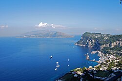
 View from Villa San Michele towards Marina Grande | |
| Coordinates: 40°33′N 14°13′E / 40.550°N 14.217°E | |
| Country | Italy |
| Region | Campania |
| Metropolitan city | Naples (NA) |
| Government | |
| • Mayor | Mario Staiano |
| Area | |
• Total | 6.39 km2 (2.47 sq mi) |
| Elevation | 275 m (902 ft) |
| Population (December 31, 2004)[2] | |
• Total | 6,240 |
| • Density | 980/km2 (2,500/sq mi) |
| Demonym | Anacaprese |
| Time zone | UTC+1 (CET) |
| • Summer (DST) | UTC+2 (CEST) |
| Postal code | 80071 |
| Dialing code | 081 |
| Patron saint | St. Anthony of Padua |
| Saint day | June 13 |
| Website | Official website |
Anacapri (Italian: [anaˈkaːpri]) is a comune on the island of Capri, in the Metropolitan City of Naples, Italy.
Anacapri is located higher on the island than Capri (about 150 m (490 ft) higher on average)[3]—the Ancient Greek prefix ana- meaning "up" or "above". Administratively, it maintains a separate status from the comune of Capri.
Anacapri is widely known for its picturesque, rural tranquility, broad views of the Bay of Naples, and significant historic sites, including Villa San Michele.
Overview
[edit]Bus and taxi services connect Marina Grande to Capri and Anacapri via the numerous hairpin turns of Via Giuseppe Orlandi.
A chairlift in Anacapri (seggiovia) connects Piazza Vittoria to the 589 m (1,932 ft) Monte Solaro, providing wide views of the south-facing coast.
Punta Carena Lighthouse is located 3 km (1.9 mi) from the main town.
French composer Claude Debussy named one of the pieces from his first book of preludes—No. 5, "Les collines d'Anacapri" ("The Hills of Anacapri")—in homage to the community.
Notable landmarks
[edit]- Casa Caprile
- Castello Barbarossa
- Belvedere della Migliera (or Migliara)
- Casa Rossa
- Chiesa di San Michele
- Chiesa di Santa Sofia
- Eremo di Santa Maria a Cetrella
- Le Boffe
- Sentiero dei fortini
- Phoenician Steps (Scala Fenicia)
- Monte Solaro
- Punta Carena Lighthouse
- Casa Cernia di Luigi Cosenza
- Villa Damecuta
- Blue Grotto
Climate
[edit]| Climate data for Anacapri (1991–2020) | |||||||||||||
|---|---|---|---|---|---|---|---|---|---|---|---|---|---|
| Month | Jan | Feb | Mar | Apr | May | Jun | Jul | Aug | Sep | Oct | Nov | Dec | Year |
| Record high °C (°F) | 20.8 (69.4) | 22.6 (72.7) | 28.2 (82.8) | 32.2 (90.0) | 36.4 (97.5) | 38.0 (100.4) | 39.8 (103.6) | 42.9 (109.2) | 36.2 (97.2) | 32.2 (90.0) | 27.6 (81.7) | 21.4 (70.5) | 42.9 (109.2) |
| Mean daily maximum °C (°F) | 13.7 (56.7) | 14.3 (57.7) | 16.8 (62.2) | 19.8 (67.6) | 24.4 (75.9) | 28.7 (83.7) | 31.7 (89.1) | 32.4 (90.3) | 28.3 (82.9) | 23.5 (74.3) | 18.3 (64.9) | 14.6 (58.3) | 22.2 (72.0) |
| Daily mean °C (°F) | 10.9 (51.6) | 10.7 (51.3) | 12.7 (54.9) | 15.4 (59.7) | 19.6 (67.3) | 23.8 (74.8) | 26.4 (79.5) | 27.0 (80.6) | 23.5 (74.3) | 19.5 (67.1) | 15.3 (59.5) | 12.0 (53.6) | 18.1 (64.6) |
| Mean daily minimum °C (°F) | 8.7 (47.7) | 8.2 (46.8) | 9.8 (49.6) | 12.1 (53.8) | 15.8 (60.4) | 19.9 (67.8) | 22.3 (72.1) | 23.0 (73.4) | 19.9 (67.8) | 16.6 (61.9) | 12.9 (55.2) | 9.9 (49.8) | 14.9 (58.8) |
| Record low °C (°F) | −0.2 (31.6) | −0.4 (31.3) | 1.2 (34.2) | 2.8 (37.0) | 8.6 (47.5) | 10.0 (50.0) | 10.0 (50.0) | 14.8 (58.6) | 10.8 (51.4) | 5.8 (42.4) | 0.0 (32.0) | 0.0 (32.0) | −0.4 (31.3) |
| Average precipitation mm (inches) | 71.4 (2.81) | 58.1 (2.29) | 52.7 (2.07) | 40.4 (1.59) | 25.8 (1.02) | 16.2 (0.64) | 10.9 (0.43) | 23.9 (0.94) | 58.4 (2.30) | 87.5 (3.44) | 95.5 (3.76) | 84.9 (3.34) | 625.7 (24.63) |
| Average precipitation days (≥ 1.0 mm) | 8.3 | 6.8 | 6.7 | 5.5 | 3.9 | 2.3 | 1.3 | 1.7 | 5.5 | 6.7 | 9.4 | 8.9 | 66.9 |
| Average relative humidity (%) | 70.5 | 68.6 | 69.7 | 69.4 | 68.4 | 67.9 | 67.1 | 67.4 | 67.3 | 70.4 | 71.9 | 70.2 | 69.1 |
| Average dew point °C (°F) | 5.5 (41.9) | 4.9 (40.8) | 7.0 (44.6) | 9.4 (48.9) | 13.1 (55.6) | 17.0 (62.6) | 19.2 (66.6) | 20.2 (68.4) | 16.7 (62.1) | 13.9 (57.0) | 10.1 (50.2) | 6.4 (43.5) | 12.0 (53.6) |
| Source: NOAA[4] | |||||||||||||
Gallery
[edit]- Anacapri viewed from the chairlift to Monte Solaro
- The Blue Grotto
- Casa Rossa
- The ruins of Villa Damecuta
- Chairlift to Monte Solaro
- View from Monte Solaro towards the Faraglioni
- Anacapri street
See also
[edit]References
[edit]- ^ "Superficie di Comuni Province e Regioni italiane al 9 ottobre 2011". Italian National Institute of Statistics. Retrieved 16 March 2019.
- ^ "Popolazione Residente al 1° Gennaio 2018". Italian National Institute of Statistics. Retrieved 16 March 2019.
- ^ "Capri Map" (PDF). Capri Tourism. Archived from the original (PDF) on 30 August 2021. Retrieved 3 May 2023.
- ^ "World Meteorological Organization Climate Normals for 1991-2020 — Capri". National Oceanic and Atmospheric Administration. Retrieved 4 February 2024.


 French
 Deutsch


