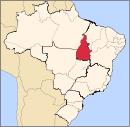
Araguatins
Araguatins | |
|---|---|
 Location in Tocantins state | |
| Coordinates: 5°39′3″S 48°7′26″W / 5.65083°S 48.12389°W | |
| Country | Brazil |
| Region | North |
| State | Tocantins |
| Founded | June 9, 1868 (as name for São Vincente do Araguaia, current name changed from 1943) |
| Government | |
| • Mayor | Claudio Carneiro Santana (PMDB) |
| Area | |
• Total | 2,627.28 km2 (1,014.40 sq mi) |
| Elevation | 103 m (338 ft) |
| Population (2020 [1]) | |
• Total | 36,170 |
| • Density | 14/km2 (36/sq mi) |
| Time zone | UTC−3 (BRT) |
Araguatins is a municipality located in the Brazilian state of Tocantins. Its population was 36,170 (2020) and its area is 2,625 km2.[2]
See also
[edit]References
[edit]- ^ "IBGE 2020". Retrieved 26 January 2021.
- ^ IBGE - [1]


 French
 Deutsch

