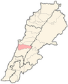
Baissour
Baissour بيصور Bayssour | |
|---|---|
| Coordinates: 33°45′55″N 35°34′03″E / 33.76528°N 35.56750°E | |
| Country | |
| Governorate | Mount Lebanon Governorate |
| District | Aley District |
| Area | |
• Total | 2.43 sq mi (6.29 km2) |
| Elevation | 2,460 ft (750 m) |
| Time zone | UTC+2 (EST) |
| • Summer (DST) | +3 |
Baissour or Bayssour, (Arabic: بيصور) is a village located in the Aley District of Mount Lebanon. It is 850 metres (2,790 ft) above sea level[1] and shares a border with Aley, Kaifoun, Kabr Shmoon, Majdlaya, and Ainab.
Baissour River (Naher Baissour, نهر بيصور) is home to many restaurants and resorts. Thousands of tourists visit Baissour every year, and along with the restaurants along the river, one of the biggest attractions is the Radar area. This beautiful, mountainous, tree covered picnic and recreational area is located at the highest point of Baissour and is accessible year round.
History
[edit]In 1838, Eli Smith noted the place, called Beisur, located in Aklim es-Sahhar, between el-Ghurb and el-Jurd.[2]
See also
[edit]References
[edit]Bibliography
[edit]External links
[edit]- Bayssour Archived 2017-11-09 at the Wayback Machine, Localiban


 French
 Deutsch
