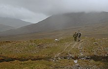
Bangor Trail
This article needs additional citations for verification. (May 2024) |

The Bangor Trail is a waymarked walking trail in Erris, North Mayo, Ireland. The trail, which is approximately 22 miles (35 km) in length,[1][2] takes a route south from Bangor Erris through the Nephin Beg Range to Newport.[3] Walking guides and maps of the Bangor Trail have been published by Mayo County Council.[4]
It is a fairly tough and remote hiking trail, in an area of largely blanket bog terrain.[5] The Bangor Trail follows an old drover path which may date from the Iron Age. There are, along the route, evidence of previous human habitation, particularly from the mid-19th century just prior to the Irish Famine.[citation needed]
The Western Way is another walking trail in the same area.
References
[edit]- ^ "Location of Bangor Erris". Mayo-ireland.ie. Archived from the original on 17 February 2011.
the "Bangor Trail" a 22 mile mountain pass
- ^ "Bangor Erris in the north of County Mayo, Ireland". Mayo-ireland.ie. Archived from the original on 11 July 2010.
Bangor Erris [..] nestles at the foot of the "Bangor Trail" a 22 mile mountain pass
- ^ "The Bangor Trail - Free Information Leaflet" (PDF). northmayo.ie. Ballycroy National Park Visitor Centre. Retrieved 6 May 2024.
- ^ "Belmullet Leisure Activities". towns.mayo-ireland.ie. Archived from the original on 16 June 2010.
Mayo County Council has published an excellent guide to the Bangor Trail, which has maps and information
- ^ "The businessman restoring a blanket bog in one of the most remote parts of Ireland". The Irish Times. Retrieved 24 March 2025.


 French
 Deutsch
