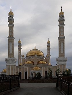
Benoy, Nozhay-Yurtovsky District, Chechen Republic
Benoy Беной Бена | |
|---|---|
Selo | |
 Mosque in Benoy | |
| Coordinates: 42°58′55″N 46°18′25″E / 42.98194°N 46.30694°E | |
| Country | Russia |
| Region | Chechnya |
| District | Nozhay-Yurtovsky District |
| Time zone | UTC+3:00 |
Benoy (Russian: Беной; Chechen: Бена, romanized: Bena) is a rural locality (a selo) and the administrative centre of Benoyskoye Rural Settlement in Nozhay-Yurtovsky District, in Chechnya, Russia. Population: 1,216 (2010 Census);[1] 2,389 (2002 Census).[2]
History
[edit]In 1944, during the Soviet era, the selo was renamed Ichichali as part of the forced deportation of the Chechen and Ingush populations, and was repopulated with people from neighboring Dagestan.[3]
However, in 1958, after the restoration of the Chechen-Ingush Autonomous Soviet Socialist Republic, the village was returned to its original name of Benoy and the Dagestani residents were resettled back to Dagestan.[4]
Geography
[edit]Benoy is located in the Chechen Republic, Russia. It is situated on the right bank of the Benoyassi River and is approximately 23 km southwest of the district center, Nozhai-Yurt and 90 km southeast of the city of Grozny. The village has neighboring settlements, including Gurzhi-Mokhk to the north, Dengi-Yurt to the northeast, Ozhi-Yurt to the east, Koren-Benoi to the south, Benoi-Vedeno to the southwest, and Pachu to the west. A notable landmark in the village is the Benoi Central Mosque.
Demography
[edit]| Year | Pop. | ±% |
|---|---|---|
| 1990 | 1,527 | — |
| 2002 | 2,389 | +56.5% |
| 2010 | 1,216 | −49.1% |
Notable residents
[edit]- Baysangur of Benoy (1794 – 1861), rebel commander
- Adam Delimkhanov (born 1969), politician
- Sulim Yamadayev (1973 – 2009), rebel and military commander
References
[edit]- ^ Russian Federal State Statistics Service (2011). Всероссийская перепись населения 2010 года. Том 1 [2010 All-Russian Population Census, vol. 1]. Всероссийская перепись населения 2010 года [2010 All-Russia Population Census] (in Russian). Federal State Statistics Service.
- ^ Federal State Statistics Service (21 May 2004). Численность населения России, субъектов Российской Федерации в составе федеральных округов, районов, городских поселений, сельских населённых пунктов – районных центров и сельских населённых пунктов с населением 3 тысячи и более человек [Population of Russia, Its Federal Districts, Federal Subjects, Districts, Urban Localities, Rural Localities—Administrative Centers, and Rural Localities with Population of Over 3,000] (XLS). Всероссийская перепись населения 2002 года [All-Russia Population Census of 2002] (in Russian).
- ^ Карта Дагестанской АССР, масштаб 1:400000. — М.: ГУГК, 1947.
- ^ "Потери вооружённых сил России и СССР в вооружённых конфликтах на Северном Кавказе (1920—2000 годы)". demoscope.ru (in Russian).


 French
 Deutsch
