Big Desert, Victoria
| Big Desert Victoria | |||||||||||||||
|---|---|---|---|---|---|---|---|---|---|---|---|---|---|---|---|
| Coordinates | 35°28′33″S 141°17′35″E / 35.47583°S 141.29306°E | ||||||||||||||
| Population | 0 (2016 census)[1] | ||||||||||||||
| Postcode(s) | 3418, 3490 | ||||||||||||||
| LGA(s) | |||||||||||||||
| State electorate(s) | Mildura | ||||||||||||||
| Federal division(s) | Mallee | ||||||||||||||
| |||||||||||||||
| Footnotes | Adjoining localities[2][3][4] | ||||||||||||||
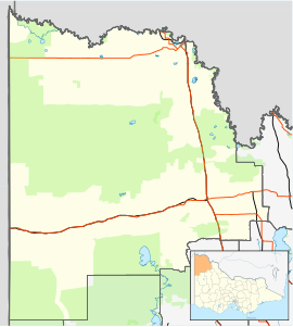
Big Desert is a locality in the Australian state of Victoria located in the state's west adjoining the border with South Australia within the local government areas of the Shire of Hindmarsh, the Rural City of Mildura and the Shire of West Wimmera. The principal land use is conservation with part of the locality being occupied by the following protected areas:
See also
[edit]References
[edit]- ^ Australian Bureau of Statistics (27 June 2017). "Big Desert (State Suburb)". 2016 Census QuickStats. Retrieved 1 September 2020.
- ^ a b "Mildura Rural City, Suburb and Rural District Names and Boundaries" (PDF). Locality names and boundary maps. Department of Environment, Land, Water and Planning, State Government of Victoria. Archived from the original (PDF) on 18 October 2015. Retrieved 21 March 2017.
- ^ a b "Shire of Hindmarsh, Locality (Suburb)Names and Boundaries" (PDF). Locality names and boundary maps. Department of Environment, Land, Water and Planning, State Government of Victoria. Archived from the original (PDF) on 10 April 2017. Retrieved 21 March 2017.
- ^ a b "West Wimmera Shire, Town and Rural District Names and Boundaries" (PDF). Locality names and boundary maps. Department of Environment, Land, Water and Planning, State Government of Victoria. Archived from the original (PDF) on 18 October 2015. Retrieved 21 March 2017.
- ^ "Search result for "Big Desert (Locality Bounded)" (Vicmap ID 100364)". Vicnames - The Register of Geographic Names. Government of Victoria. Retrieved 21 March 2017.


 French
 Deutsch


