
 French
 Deutsch
Burr Pond State Park
| Burr Pond State Park | |
|---|---|
 | |
 Burr Pond State Park Location in Connecticut  Burr Pond State Park Burr Pond State Park (the United States) | |
| Location | Torrington, Connecticut, United States |
| Coordinates | 41°52′10″N 73°05′50″W / 41.86944°N 73.09722°W[1] |
| Area | 438 acres (177 ha)[2] |
| Elevation | 988 ft (301 m)[1] |
| Established | 1949 |
| Administered by | Connecticut Department of Energy and Environmental Protection |
| Designation | Connecticut state park |
| Website | Official website |
Burr Pond State Park is a public recreation area covering 438 acres (177 ha) adjacent to Paugnut State Forest in the town of Torrington, Connecticut. The state park surrounds Burr Pond, an 85-acre (34 ha),[3] man-made body of water with facilities for swimming, boating, and fishing. It is managed by the Connecticut Department of Energy and Environmental Protection.[4]
History
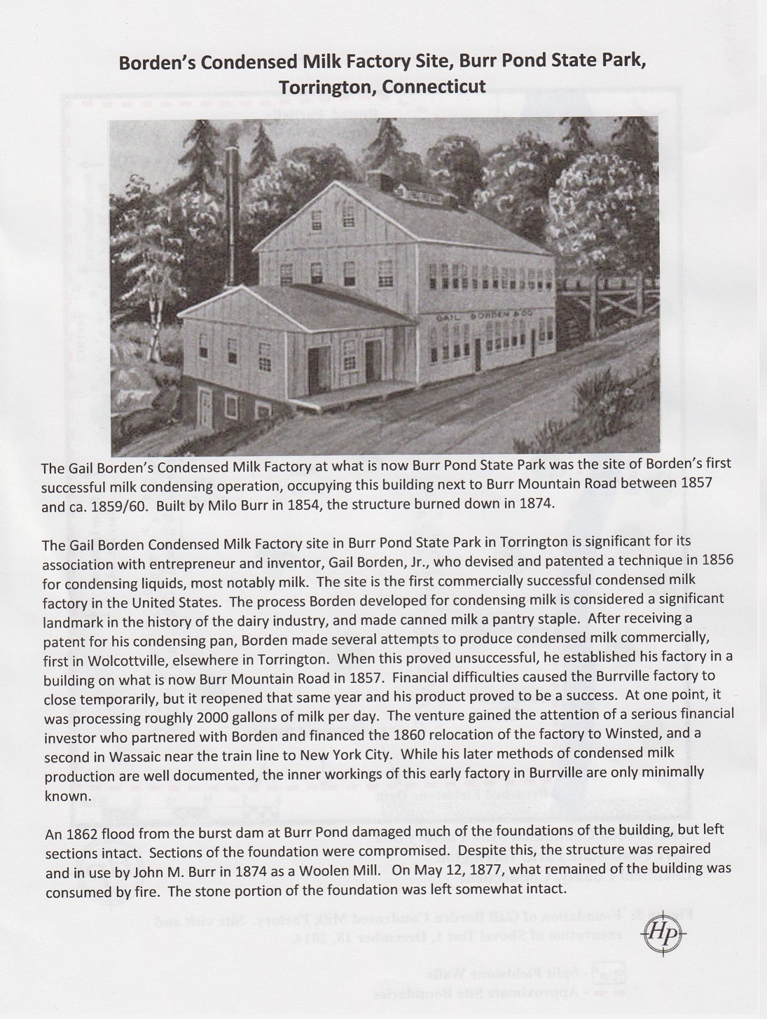
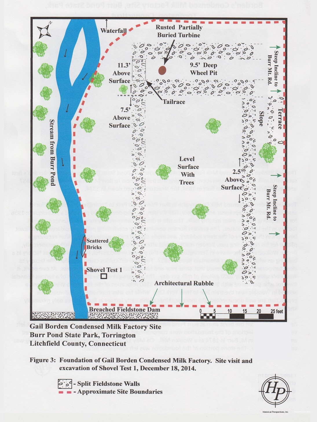
[edit]Burr Pond was created in 1851 when Milo Burr dammed several streams to create a source for power generation. The waterpower was used to operate a tannery and three sawmills.[5] One of Burr's industrial buildings was used from 1857 to 1861 by Gail Borden as his first commercially successful condensed milk factory. The building burned down in 1877; the remains of its stone foundations can be seen off Burr Mountain Road.[6][7]
Burr Pond and the area around it were once part of Paugnut State Forest.[8] The acreage was transferred to the State Parks Division and became a state park in 1949.[5]
Activities and amenities
[edit]Burr Pond has several small inlets and islands, a rocky shore, and deep drop-offs in several places. Its maximum depth is only 13 feet (4.0 m). Fish species present include largemouth bass, chain pickerel, black crappie, yellow perch, bluegill, pumpkinseed, and brown bullhead.[4]
The blue-blazed Walcott Trail 2.5-mile-long (4.0 km) loop goes around the pond.[8] The 2-mile-long (3.2 km) John Muir Trail across Paugnut State Forest connects the park with Sunnybrook State Park.[9]
A swimming beach, picnic areas, concession stand, and boat rentals are offered seasonally.[10] A trailered boat launch is located at the pond's north end.[11]
References
[edit]- ^ a b "Burr Pond". Geographic Names Information System. United States Geological Survey, United States Department of the Interior.
- ^ "Appendix A: List of State Parks and Forests" (PDF). State Parks and Forests: Funding. Staff Findings and Recommendations. Connecticut General Assembly. January 23, 2014. p. A-1. Retrieved March 20, 2014.
- ^ "Burr Pond" (PDF). Connecticut Department of Energy and Environmental Protection. September 2011. Retrieved October 24, 2017.
- ^ a b "Burr Pond State Park". Connecticut Department of Energy and Environmental Protection. Retrieved August 4, 2024.
- ^ a b "Burr Pond State Park". State Parks and Forests. Connecticut Department of Energy and Environmental Protection. Archived from the original on January 9, 2015. Retrieved October 24, 2017.
- ^ "Borden's Condensed Milk Factory Site". Historical Perspectives. Friends of the Office of State Archaeology. Retrieved July 1, 2015.
- ^ "Borden's Condensed Milk Factory Site Plan". Historical Perspectives. Friends of the Office of State Archaeology. Retrieved July 1, 2015.
- ^ a b "Clues for Paugnut State Forest". Connecticut State Forests Seedling Letterbox Series. Connecticut Department of Energy and Environmental Protection. July 7, 2016. Retrieved July 13, 2016.
- ^ "Paugnut State Forest: John Muir Trail" (PDF). Connecticut Bureau of Outdoor Recreation, State Parks Division. 2008. Retrieved August 4, 2024.
- ^ "Canoe & Kayak Rental at Burr Pond and Lake Waramaug State Parks". Connecticut Department of Energy and Environmental Protection. Retrieved August 4, 2024.
- ^ "Burr Pond Boat Launch". Connecticut Department of Energy and Environmental Protection. January 12, 2023. Retrieved August 4, 2024.
External links
[edit]- Burr Pond State Park Connecticut Department of Energy and Environmental Protection
- Burr Pond State Park Map Connecticut Department of Energy and Environmental Protection