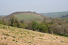
Cadson Bury
 Viewed from Lower Crift, about 0.75 miles (1.2 km) to the south | |
| Location | Near Callington, Cornwall |
|---|---|
| Coordinates | 50°28′57″N 4°20′5″W / 50.48250°N 4.33472°W |
| OS grid reference | SX 344 673 |
| Type | Hillfort |
| Length | 275 metres (902 ft) |
| Width | 170 metres (558 ft) |
| Area | 2.5 hectares (6.2 acres) |
| History | |
| Periods | Iron Age |
| Designated | 24 October 1950 |
| Reference no. | 1004494 |
| Identifiers | |
| Atlas of Hillforts | 0607 |
Cadson Bury is an Iron Age hillfort about 2 miles (3.2 km) south-west of Callington, in Cornwall, England.
It is owned by the National Trust,[1] and it is scheduled monument.[2]
Description
[edit]The fort is sited in a commanding position on a steep hill, called Cadson Bury Down, above the River Lynher.[2]
It is univallate, probably of the early Iron Age.[3] The oval enclosure, longest from north to south, is about 275 metres (902 ft) long and 170 metres (558 ft) wide, enclosing an area of about 2.5 hectares (6.2 acres). The rampart is up to 2 metres (6 ft 7 in) above the interior; the outer ditch is about 1.3 metres (4 ft 3 in) deep on the east side, less visible elsewhere.[1][2]

There are no traces of house platforms within the enclosure. There are two opposed inturned entrances on the east and west sides; the eastern entrance is clearly defined, the western entrance less so. Another entrance on the south may not be original.[1][2][4]
See also
[edit]References
[edit]- ^ a b c Cadsonbury Camp, Cadsonbury National Trust Heritage Records Online. Retrieved 16 November 2017.
- ^ a b c d Historic England. "Slight univallate hillfort called Cadson Bury (1004494)". National Heritage List for England. Retrieved 16 November 2017.
- ^ Richard Wainwright. A Guide to the Prehistoric Remains in Britain. Volume 1: South and East. Constable, 1979. Page 42.
- ^ Cornwall's Archaeological Heritage. The Historic Environment Unit, Cornwall County Council, 2003. Page 22.


 French
 Deutsch