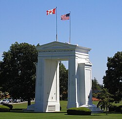
Canada–United States border
| Canada–United States border | |
|---|---|
 | |
| Characteristics | |
| Entities | |
| Length | 8,891 km (5,525 mi) |
| History | |
| Established | September 3, 1783 Signing of the Treaty of Paris at the end of the American War of Independence |
| Current shape | April 11, 1908 Treaty of 1908 |
| Treaties | |
| Notes | See list of current disputes |
The international border between Canada and the United States is the longest in the world by total length.[a] The boundary (including boundaries in the Great Lakes, Atlantic, and Pacific coasts) is 8,891 km (5,525 mi) long. The land border has two sections: Canada's border with the northern tier of the contiguous United States to its south, and with the U.S. state of Alaska to its west. The bi-national International Boundary Commission deals with matters relating to marking and maintaining the boundary, and the International Joint Commission deals with issues concerning boundary waters. The agencies responsible for facilitating legal passage through the international boundary are the Canada Border Services Agency (CBSA) and U.S. Customs and Border Protection (CBP).

History
[edit]18th century
[edit]
The Treaty of Paris of 1783 ended the American Revolutionary War between Great Britain and the United States. In the second article of the Treaty, the parties agreed on all boundaries of the United States, including, but not limited to, the boundary to the north along what was then British North America. The agreed-upon boundary included the line from the northwest angle of Nova Scotia to the northwesternmost head of the Connecticut River and proceeded down along the middle of the river to the 45th parallel of north latitude.
The parallel had been established in the 1760s as the boundary between the provinces of Quebec and New York (including what would later become the State of Vermont). It was surveyed and marked by John Collins and Thomas Valentine from 1771 to 1773.


 French
 Deutsch