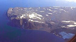
Cape Brewster
Cape Brewster Kangikajik (Greenlandic) | |
|---|---|
 | |
| Coordinates: 70°9′N 22°3′W / 70.150°N 22.050°W | |
| Location | Sermersooq, Greenland |
| Offshore water bodies | Greenland Sea |
| Native name | Kangikajik (Greenlandic) |
| Area | |
| • Total | Arctic |
| Elevation | 1200 |
Cape Brewster (Danish: Kap Brewster; Greenlandic: Kangikajik, meaning 'the bad cape') is a headland in the Greenland Sea, east Greenland, Sermersooq municipality.
History
[edit]This headland was named Cape Brewster by William Scoresby (1789 – 1857) in 1822 to honour his friend, inventor David Brewster (1781–1868).[1]
Geography
[edit]Cape Brewster is the easternmost point of the jagged and mountainous Savoia Peninsula and the northernmost point of the Blosseville Coast.[2]
It is located at the end of the southern side of the mouth of the Scoresby Sound, opposite Cape Tobin (Uunarteq).[3] The cape lies in the desolate and impressive area of the southern shore of the sound with steep dark basalt walls rising between 1,000 and 2,000 m (3,280-6,560 ft).[4]
 |
See also
[edit]References
[edit]- ^ Place names, NE Greenland
- ^ Prostar Sailing Directions 2005 Greenland and Iceland Enroute, p. 111
- ^ Kap Tobin
- ^ Kap Brewster


 French
 Deutsch