Costa Oriental del Lago de Maracaibo
Costa Oriental del Lago de Maracaibo (Costa Oriental del Lago) | |
|---|---|
 Ciudad Ojeda | |
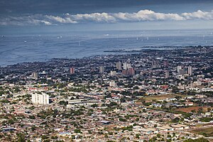
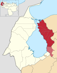
 Map of the Administrative division of Costa Oriental del Lago. | |
| Country | |
| State | |
| Largest Cities | Cabimas Ciudad Ojeda |
| Area | |
| • Metro | 8,251 km2 (3,186 sq mi) |
| Population | |
| 758,957 | |
| • Metro | 910,752 |
| • Metro density | 110.38/km2 (285.9/sq mi) |
| Time zone | UTC-4:30 (VST) |
Costa Oriental del Lago de Maracaibo (in English Eastern Coast of Maracaibo Lake) is a metropolitan area and subregion, that includes seven municipalities of Zulia state. It is the main traditional area of the oil industry in Zulia and where most oilfield operations are based. It's bordered to the west by Lake Maracaibo, the east with the states of Falcón and Lara, the north with the Gulf of Venezuela, and the south with Trujillo state. The "COL" conurbation has 758,957 inhabitants, while the "COL" as a subregion has 910,752 inhabitants.
Cities
[edit]It is a densely populated area covering approximately one third of the population of Zulia state (almost one million), with 2 large cities and numerous towns and villages. The principal cities of the area are:[1]

- Cabimas (pop. 280,171)[2]
- Ciudad Ojeda (pop. 152,890)[3]
- Mene Grande (pop. 61,960)[4]
- Los Puertos de Altagracia (pop. approx. 56,210)[5]
- Lagunillas (pop. 53,717)[6]
- Bachaquero (pop. 48,402)[7]
- Santa Rita (pop. 30,777)
- El Danto (pop. 30,022)
- Tía Juana (pop. 24,775)[8]
- Sabaneta de Palmas (pop. 20,033)[9]
Municipalities
[edit]The 7 municipalities of the area are:
| Municipality | Area (km2)[10] | Population 2013 [1] | Population density 2013 (/km2) |
|---|---|---|---|
| Miranda | 1966 | 101,248 | 51.49 |
| Santa Rita | 505 | 54,748 | 108.41 |
| Cabimas | 604 | 299,108 | 495.21 |
| Simón Bolívar | 258 | 47,535 | 184.24 |
| Lagunillas | 975 | 245,283 | 251.57 |
| Valmore Rodriguez | 1127 | 64,918 | 57.65 |
| Baralt | 2816 | 97.912 | 34.76 |
| Costa Oriental del Lago | 8251 | 910,752 | 110.38 |
See also
[edit]References
[edit]- Humberto Ochoa Urdaneta. (1995). Memoria Geográfica de la Costa Oriental del Lago de Maracaibo.
- Emilio Strauss, William Fuenmayor, José Romero. (2000). Atlas del Estado Zulia.
- https://web.archive.org/web/20121107023045/http://www.ine.gov.ve/seccion/menuprincipal.asp?nedo=24&Entid=230000&seccion=1&nvalor=1_1
- ^ a b c http://www.cne.gov.ve/web/normativa_electoral/elecciones/2013/municipales/circunscripciones/Zulia.pdf [bare URL PDF]
- ^ La ciudad de Cabimas ocupa todas las parroquias con excepción de Arístides Calvani que es el área rural y Punta Gorda ocupada por el pueblo de Punta Gorda.
- ^ Population of the parishes Alonso Ojeda and Libertad
- ^ Population of the parishes Libertador, Pueblo Nuevo and Marcelino Briceño
- ^ Population of the Parish Altagracia
- ^ Population of the Parish Venezuela
- ^ Population of the parishes Rafael Urdaneta and La Victoria
- ^ Population of the Parish Manuel Manrique
- ^ Population of the Parish San Jose of Miranda Municipality
- ^ http://www.ine.gob.ve/documentos/see/sintesisestadistica2011/estados/zulia/index.htm Sintesis Estadistica de Zulia: POBLACIÓN
10°38′00″N 71°38′00″W / 10.6333°N 71.6333°W


 French
 Deutsch