Denistone West, New South Wales
| Denistone West Sydney, New South Wales | |||||||||||||||
|---|---|---|---|---|---|---|---|---|---|---|---|---|---|---|---|
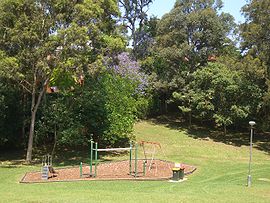
 West Denistone Park | |||||||||||||||
 | |||||||||||||||
| Population | 947 (SAL 2021)[1] | ||||||||||||||
| Established | 5 February 1999[2] | ||||||||||||||
| Postcode(s) | 2114 | ||||||||||||||
| Elevation | 62 m (203 ft) | ||||||||||||||
| Area | 0.3 km2 (0.1 sq mi)[3] | ||||||||||||||
| Location | 16 km (10 mi) north-west of Sydney CBD | ||||||||||||||
| LGA(s) | City of Ryde | ||||||||||||||
| State electorate(s) | Ryde | ||||||||||||||
| Federal division(s) | Bennelong | ||||||||||||||
| |||||||||||||||
Denistone West is a suburb in Northern Sydney, in the state of New South Wales, Australia. Denistone West is located 16 kilometres north-west of the Sydney central business district in the local government area of the City of Ryde. Denistone and Denistone East are separate suburbs; Denistone West was gazetted as a suburb in its own right on 5 February 1999.[4]
Parks
[edit]Denistone West has several parks, including West Denistone Park, Lynn Park, Rutherford Park and Hibble Park. West Denistone Park was featured briefly in an episode of Season 43 of Play School on the ABC.
Transport
[edit]Denistone railway station is situated in the suburb of Denistone. Denistone West is serviced by one Busways routes, 544, which connect to Eastwood, Auburn and Macquarie Park.
At the 2021 census, 4.2% of employed people travelled to work on public transport and 35.8% by motor vehicle and 44.7% of people worked from home (these statistics may be affected by the COVID-19 lockdown in New South Wales); this is in comparison to the 2016 Census when 66.8% of people were driving to work, 23.9% used public transport - 18.7% of those used the train at some part of their journey - and 3.2% of people worked from home.[5][6]
Commercial
[edit]The commercial and retail hub of Denistone West is the West Denistone Shopping Centre. Major tenants include a vet & a hairdresser. An Australia Post post box is installed nearby the centre.[7] The shopping area also includes a small car park.
Demographics
[edit]Source:[5]
Population
[edit]- As of the 2021 census Denistone West had a population of 947 people and 0.5% of respondents identifying as aboriginal.
- The distribution of ages in Denistone West was reasonably similar to the country as a whole. The median age was 42 years, compared to the national median of 38. Children aged under 15 years made up 20.2% of the population (the national average was 18.2%) and people aged 65 years and over made up 19.0% of the population (the national average was 17.2%).
Ethnic diversity
[edit]- 58.9% of people were born in Australia. The next most common countries of birth were China (excluding Special Administrative Regions and Taiwan) at 11.9%, South Korea at 3.6%, Hong Kong (SAR of China) at 3.1%, England at 2.3% and India at 2.1%.
- 54.3% of residents only spoke English at home, other languages spoken at home included Mandarin at 12.8%, Cantonese at 8.2%, Korean at 4.0%, Arabic at 3.6% and Greek at 0.8%.
Religion
[edit]- The most common responses for religion were No Religion at 33.9%, Catholic at 30.4%, Anglican at 13.8%, Buddhism at 3.4% and Uniting Church at 3.1%.
Income
[edit]- Denistone West had an average household income of $2,579 (the national average for the 2021 Census was $1,746), a personal income of $855 (the national average for the 2021 Census was $805) and a family income of $2,750 (the national average for the 2021 Census was $2,120).
Housing
[edit]- The great majority (86.4%) of private dwellings in Denistone West were family households. Separate houses accounted for 96.0% of dwellings, with 2.0% of private dwellings being semi-detached houses (such as a townhouse or row or terrace house) and apartments and flats making up 2.3% of private dwellings. The average household size was 3.1 people.
Media
[edit]Two free newspapers are home delivered weekly, the Northern District Times and The Weekly Times.
References
[edit]- ^ Australian Bureau of Statistics (28 June 2022). "Denistone West (suburb and locality)". Australian Census 2021 QuickStats. Retrieved 28 June 2022.
- ^ "Geographical Names Register Extract". Geographical Names Board of New South Wales. Retrieved 8 February 2016.
- ^ Australian Bureau of Statistics (27 June 2017). "2016 Community Profiles: Denistone West (State Suburb)". 2016 Census of Population and Housing. Retrieved 19 March 2018.
- ^ "Geographical Names Register Extract". Geographical Names Board of New South Wales. Retrieved 26 April 2014.
- ^ a b Australian Bureau of Statistics (28 June 2022). "Denistone West". 2021 Census QuickStats. Retrieved 17 May 2024.
- ^ Australian Bureau of Statistics (27 June 2017). "Densitone West". 2016 Census QuickStats. Retrieved 17 May 2024.
- ^ The Book of Sydney Suburbs (2nd Edition), Compiled by Frances Pollen, Angus & Robertson Publishers, 2011, Published in Australia ISBN 0-207-14495-8, page 83[better source needed]
External links
[edit]- Angela Phippen (2010). "Denistone West". Dictionary of Sydney. Retrieved 27 September 2015. [CC-By-SA]


 French
 Deutsch