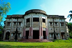
Dhupchanchia Upazila
Dhupchanchia দুপচাঁচিয়া | |
|---|---|
 Gunahar Zamindar Bari | |
 | |
| Coordinates: 24°52′N 89°10′E / 24.867°N 89.167°E | |
| Country | |
| Division | Rajshahi |
| District | Bogra |
| Area | |
• Total | 162.44 km2 (62.72 sq mi) |
| Population | |
• Total | 195,075 |
| • Density | 1,200/km2 (3,100/sq mi) |
| Time zone | UTC+6 (BST) |
| Postal code | 5880[3] |
| Area code | 05024[4] |
| Website | dupchanchia |
Dhupchanchia Upazila (Bengali: দুপচাঁচিয়া উপজেলা) is an upazila of Bogra District in the Division of Rajshahi, Bangladesh. Dhupchanchia Thana was established in 1880 and was converted into an upazila in 1983.[5] It is named after its administrative center, the town of Dhupchanchia.
Geography
[edit]Dhupchanchia Upazila has a total area of 162.44 square kilometres (62.72 sq mi).[1] It is bounded on the east by the Nagar River (across which lies Kahaloo Upazila).[5] It borders Adamdighi Upazila to the south and west, Joypurhat District to the west and north, and Shibganj Upazila to the northeast.[5]
Dhupchanchia Municipality has an area of 10.21 square kilometres (3.94 sq mi).[5] It is situated about 20 km (12 mi) from the principal town of the District, Bogra.
Demographics
[edit]| Year | Pop. (000) | ±% |
|---|---|---|
| 1981 | 122 | — |
| 1991 | 149 | +22.1% |
| 2001 | 161 | +8.1% |
| 2011 | 177 | +9.9% |
| 2022 | 195 | +10.2% |
| Source: Bangladesh Bureau of Statistics[1] | ||
According to the 2011 Census of Bangladesh, Dhupchanchia Upazila had 45,390 households and a population of 176,678. 33,157 (18.77%) were under 10 years of age. Dhupchanchia had a literacy rate (age 7 and over) of 51.69%, compared to the national average of 51.8%, and a sex ratio of 1029 females per 1000 males. 22,406 (12.68%) lived in urban areas.[1][7]
Economy
[edit]This section needs expansion with: a description of this upazila's economy, why these markets are important, and details about the markets. Cite reliable sources. You can help by adding to it. (July 2014) |
Hats and bazar
[edit]Hats and bazars are 15, the most noted of which are Dhap sultangonj Hat, Taluch Hat, Zianagar Hat, Talora Hat, and Saharpukur Hat, Chowmohoni Hat and Bazar. And bazars are open every day, the most noted bazar are tematha puraton bazar, c.o office bazar etc.
Main exports
[edit]Paddy, rice, potato, biscuit, fish, milk, wood, vegetables etc.

Points of interest
[edit]- Dargah of Sultan Shahi Sawar Dhap
- Gobindapur Temple
- Goyabandh Mazar
- Mazar of Pir Ziauddin[5]
- Bhathanda Syed Mir Shaheb Mazar
- It is said that the Mazar of Mir Shaheb of Bhathanda village has a strange fruit tree called Khiri tree.
Administration
[edit]Dhupchanchia Upazila is divided into two municipalities and six union parishads: Chamrul, Dhupchanchia, Gobindapur, Gunahar, Talora, and Zianagar. The union parishads are subdivided into 108 mauzas and 212 villages.[1]
Dupchanchia Municipality was established in 2000. It has 9 wards and 37 mahallas.[5] Md. Jahangir Alom (Bangladesh Nationalist Party) was elected mayor in 2008.[8][9] Upazila Nirbahi Officer (UNO) Shahrukh Khan assumed office as the Municipal Administrator on January 19, 2025.
Talora Municipalicity was established in 2013.[10]
Infrastructure
[edit]This section needs expansion with: a description of why these particular health centers are important. Cite reliable sources. You can help by adding to it. (July 2014) |
Transport
[edit]Railway stations Altafnagar and Talora are on the branch line connecting Santahar and Kaunia. In July 2014 they were served by six or eight intercity and six mail trains a day.[11]
Health centres
[edit]Upazila health complex 1, rural health centre 1, satellite clinic 1, family welfare centre 5.
Education
[edit]According to Banglapedia, Talora Altaf Ali High School, founded in 1918, Dupchanchia Pilot High School, founded in 1923, and Dupchanchia Pilot Girls' High School, founded in 1910, are notable secondary schools.[5] There are six colleges in the upazila. They include Dupchanchia J.K. Degree College, and Shahid M Monsur Ali College. Dupchanchia Mohila Degree College, founded in 1993, is the only honors level college in the upazila.[1][12]
The madrasa education system includes four fazil madrasas.[13]
See also
[edit]References
[edit]- ^ a b c d e f "Bangladesh Population and Housing Census 2011 Zila Report – Bogra" (PDF). bbs.gov.bd. Bangladesh Bureau of Statistics.
- ^ National Report (PDF). Population and Housing Census 2022. Vol. 1. Dhaka: Bangladesh Bureau of Statistics. November 2023. p. 401. ISBN 978-9844752016.
- ^ "Bangladesh Postal Code". Dhaka: Bangladesh Postal Department under the Department of Posts and Telecommunications of the Ministry of Posts, Telecommunications and Information Technology of the People's Republic of Bangladesh. 21 October 2024.
- ^ "Bangladesh Area Code". China: Chahaoba.com. 18 October 2024.
- ^ a b c d e f g Pulak, Md Khairul Alam (2012). "Dhupchanchia Upazila". In Islam, Sirajul; Jamal, Ahmed A. (eds.). Banglapedia: National Encyclopedia of Bangladesh (Second ed.). Asiatic Society of Bangladesh.
- ^ Population and Housing Census 2022 - District Report: Bogura (PDF). District Series. Dhaka: Bangladesh Bureau of Statistics. June 2024. ISBN 978-984-475-235-1.
- ^ "Community Tables: Bogra district" (PDF). bbs.gov.bd. Bangladesh Bureau of Statistics. 2011.
- ^ "Dhupchanchia Municipality at a Glance". Dhupchanchia Upazila. Archived from the original on February 3, 2014. Retrieved July 16, 2014.
- ^ "BNP Leader Elected Mayor". Bangladesh News. Archived from the original on July 24, 2014. Retrieved July 17, 2014.
- ^ "Talora Municipality Election Today". The Daily Star. Retrieved July 17, 2014.
- ^ "Santahar Schedule". Bangladesh Railways. Retrieved August 8, 2014.
- ^ "Dupchanchia Mohila College - Home". Dupchanchia Mohila College. Archived from the original on July 26, 2014. Retrieved July 16, 2014.
- ^ "List of Institutions". Ministry of Education. Retrieved July 15, 2014.


 French
 Deutsch