Sections of Billings, Montana

The city of Billings, Montana is subdivided into 11 sections for geographic and planning purposes.
Downtown Core
[edit]
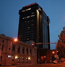
This is the main financial, business, cultural and medical area of Billings and the surrounding areas and is home to several high-rise buildings including Montana's tallest high-rise, the First Interstate Center.
Neighborhoods in this section:
- East Downtown
- Historic District
- Fairgrounds
- West Downtown
- China Alley
- Medical Corridor
- Cathedral District
- Civic District
- MSU-Billings
- Bottom Westend Historic District
- North Side
- North Park
- Dehler Park
- South Side
- Old Town
- South Park
- Phillips (Named after the Phillips 66 Refinery)
- Refinery
Heights
[edit]Located Northeast of the Downtown Core, was annexed into the city in the mid-1980s. This area is where the Lake Hills Golf Course.
Neighborhoods in this section:
- East Heights
- Bench
- West Heights
- Lake Hills
- Moon Valley
Northeast
[edit]Northeast is bordered by Roundup Road, Mary Street, Dury Lane and the Yellowstone River. Located northeast of the Heights.
North Elevation
[edit]This area is where the Rimrocks rise up above the Yellowstone Valley.
Neighborhoods in this section:
- BIL-Airport
- Zimmerman
- Rehberg Ranch
- Indian Cliffs
Terry
[edit]This area is where Central and Terry parks are located. Also where Billings Central Catholic High School is located.
Neighborhoods in this section:
- Terry Park
- Central Park
- Highlands Country Club
- Rocky Mountain College
- College Streets
- Tree Streets
- Poet Streets
West End
[edit]Widely known as the West End or West Side, this is one of the fastest-growing areas in Billings. The West End is the home of Rimrock Mall and Billings West High School, the home of the Bears. The local middle school is Will James, and Meadowlark Elementary is for K-6 graders.
Neighborhoods in this section:
- Mid-town
- Overland Business Park
- Gorham Park
- Central Heights
- Olympic Park
- TransTech Center
- Southgate Business park
- The Industrial Sites
- Wilshire Heights
- Lillis Heights
- West Ridge
Southwest
[edit]It will soon be the location for a new retail/commercial development called Billings Town Square in which Cabelas will be the anchor tenant.
Neighborhoods in this section:
- South Hills
- Riverfront
- Briarwood
- Josephine Crossing
- Southwest Subdivision
- Blue Creek
- Duck Creek
South Central
[edit]This section is empty. You can help by adding to it. (March 2013) |
Northwest
[edit]This area typically encompasses the area north of Grand Avenue and west of Shiloh. This area tends to be the more affluent part of town.
Neighborhoods in this section:
- Yellowstone Country Club
- Augusta Ranch
- Copper Ridge
- Mount Vista
- Falcon Ridge
- Ironwood
Shiloh
[edit]It is located to the west of the West End - Descro area, and is centered around Shiloh Road, a north–south arterial which in 2008 underwent a major widening project that included the addition of 7 roundabouts. Near the southern part of this section of Billings, south of King Avenue West, a shopping district called Shiloh Crossing was built around the same time, consisting of a movie theater and various restaurants, shops and department stores including Kohl's.
Neighborhoods in this section:
- North Shiloh
- Vintage Estates
- Grand Peaks
- Cloverleaf Meadows
- Shiloh Point
- Rush Subdivision
- Fox Tail Village
- South Shiloh
- Shiloh Industrial Park
Outlying North
[edit]This area is located north of the Airport and west of the Heights and is where the Inner Belt Loop is proposed to link the West End to the Heights.
Neighborhoods in this section:
- Alkali Creek
Lockwood
[edit]Lockwood is a Billings suburb located to the east with access to I90. Lockwood has grown to become the largest unincorporated community in the state of Montana and the 16th largest population center in the state. This area is where the Billings Bypass will join the Lockwood area to the Heights via a new interchange on I90.
Shepherd
[edit]Shepherd is a Billings suburb located to the northeast off of highway 312. The unincorporated town was named after R.E. Shepherd, a prominent early settler and owner of the Billings Land and Irrigation Company and the Merchants National Bank.


 French
 Deutsch