Dropt
| Dropt | |
|---|---|
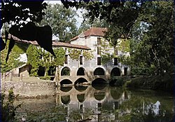
 Moulin de Loubens sur le Dropt | |
| Physical characteristics | |
| Source | |
| • location | Massif Central |
| • coordinates | 44°41′9″N 0°57′24″E / 44.68583°N 0.95667°E |
| • elevation | 239 m (784 ft) |
| Mouth | |
• location | Garonne |
• coordinates | 44°34′58″N 0°6′35″W / 44.58278°N 0.10972°W |
| Length | 132 km (82 mi) |
| Basin size | 1,500 km2 (580 sq mi) |
| Discharge | |
| • average | 4.5 m3/s (160 cu ft/s) |
| Basin features | |
| Progression | Garonne→ Gironde estuary→ Atlantic Ocean |
The Drot or Dropt (French pronunciation: [dʁo]) is a river in Nouvelle-Aquitaine, France. It is a right tributary to the Garonne. It is 132 km (82 mi) long.[1]
Geography
[edit]The source of the Dropt is located near Capdrot in the Dordogne. The drainage basin covers the area between the river valleys of the Lot and the Dordogne.
References
[edit]External links
[edit]


 French
 Deutsch
