Electoral district of Nudgee
| Nudgee Queensland—Legislative Assembly | |||||||||||||||
|---|---|---|---|---|---|---|---|---|---|---|---|---|---|---|---|
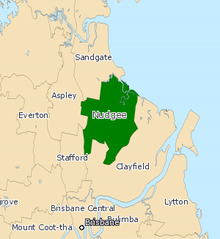
 Electoral map of Nudgee 2017 | |||||||||||||||
| State | Queensland | ||||||||||||||
| Dates current | 1960–present | ||||||||||||||
| MP | Leanne Linard | ||||||||||||||
| Party | Labor | ||||||||||||||
| Namesake | Nudgee | ||||||||||||||
| Electors | 37,845 (2020) | ||||||||||||||
| Area | 42 km2 (16.2 sq mi) | ||||||||||||||
| Demographic | Outer-metropolitan | ||||||||||||||
| Coordinates | 27°22′S 153°4′E / 27.367°S 153.067°E | ||||||||||||||
| |||||||||||||||

Nudgee is an electoral district of the Legislative Assembly in the Australian state of Queensland. It is located in the north-eastern suburbs of Brisbane.[1]
Members for Nudgee
[edit]| Member | Party | Term | |
|---|---|---|---|
| Jack Melloy | Labor | 1960–1977 | |
| Ken Vaughan | Labor | 1977–1995 | |
| Neil Roberts | Labor | 1995–2012 | |
| Jason Woodforth | Liberal National | 2012–2015 | |
| Leanne Linard | Labor | 2015–present | |
Election results
[edit]| Party | Candidate | Votes | % | ±% | |
|---|---|---|---|---|---|
| Labor | Leanne Linard | 16,860 | 48.20 | −3.30 | |
| Liberal National | Robert Wilson | 11,137 | 31.84 | +1.84 | |
| Greens | Jim Davies | 4,721 | 13.50 | +0.30 | |
| One Nation | Joshua Baer | 1,248 | 3.57 | +0.07 | |
| Family First | Sharan Hall | 591 | 1.69 | +1.69 | |
| Independent | Bruce Tanti | 419 | 1.20 | +1.20 | |
| Total formal votes | 34,976 | 97.08 | |||
| Informal votes | 1,053 | 2.92 | |||
| Turnout | 36,029 | 89.80 | |||
| Two-party-preferred result | |||||
| Labor | Leanne Linard | 21,686 | 62.00 | −3.10 | |
| Liberal National | Robert Wilson | 13,290 | 38.00 | +3.10 | |
| Labor hold | Swing | -3.10 | |||
References
[edit]- ^ "Representatives of Queensland State Electorates 1860-2017" (PDF). Queensland Parliamentary Record 2012-2017: The 55th Parliament. Queensland Parliament. Archived from the original (PDF) on 27 April 2020.
- ^ "Nudgee - QLD Electorate, Candidates, Results". abc.net.au. 27 October 2024. Retrieved 14 December 2024.


 French
 Deutsch