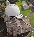
File:Aerial view of McClean telescope building.jpg
Aerial_view_of_McClean_telescope_building.jpg (409 × 441 pixels, file size: 45 KB, MIME type: image/jpeg)
File history
Click on a date/time to view the file as it appeared at that time.
| Date/Time | Thumbnail | Dimensions | User | Comment | |
|---|---|---|---|---|---|
| current | 19:44, 27 March 2015 |  | 409 × 441 (45 KB) | Capester | {{Information |Description ={{en|1=Aerial view of McClean telescope building, former Royal Observatory, Cape of Good Hope}} |Source =Photo by Janus Brink |Author =Janus Brink |Date =21 March 2015 |Permission =CC0 1.0 |o... |
File usage
The following page uses this file:
Global file usage
The following other wikis use this file:
- Usage on de.wikipedia.org
- Usage on es.wikipedia.org
- Usage on he.wikipedia.org
- Usage on incubator.wikimedia.org
- Usage on it.wikipedia.org
- Usage on ja.wikipedia.org
- Usage on ms.wikipedia.org
- Usage on ne.wikipedia.org
- Usage on pt.wikipedia.org
- Usage on sah.wikipedia.org
- Usage on uk.wikipedia.org
- Usage on zh.wikipedia.org


 French
 Deutsch