File:AncientEgyptJamesRennell01.jpg

Size of this preview: 541 × 599 pixels. Other resolutions: 217 × 240 pixels | 433 × 480 pixels | 693 × 768 pixels | 924 × 1,024 pixels | 1,548 × 1,715 pixels.
Original file (1,548 × 1,715 pixels, file size: 384 KB, MIME type: image/jpeg)
File history
Click on a date/time to view the file as it appeared at that time.
| Date/Time | Thumbnail | Dimensions | User | Comment | |
|---|---|---|---|---|---|
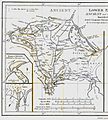
| current | 19:23, 12 August 2010 |  | 1,548 × 1,715 (384 KB) | CarlDrews~commonswiki | {{Information |Description={{en|1=Map of ancient Egypt created by James Rennell as an insert for his book "The geographical system of Herodotus examined and explained" (published 1800 and 1830). This map shows Rennell's understanding of the geography of E |
File usage
The following 4 pages use this file:
Global file usage
The following other wikis use this file:
- Usage on ar.wikipedia.org
- Usage on bg.wikipedia.org
- Usage on de.wikipedia.org
- Usage on el.wikipedia.org
- Usage on es.wikipedia.org
- Usage on fr.wikipedia.org
- Usage on he.wikipedia.org
- Usage on ja.wikipedia.org
- Usage on ja.wikibooks.org
- Usage on nl.wikipedia.org
- Usage on sl.wikipedia.org
- Usage on tr.wikipedia.org
- Usage on uk.wikipedia.org
- Usage on zh.wikipedia.org


 French
 Deutsch