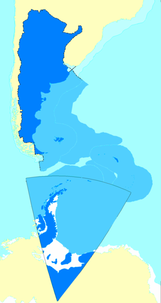
File:Argentine map of Argentina.png

Size of this preview: 320 × 599 pixels. Other resolutions: 256 × 480 pixels | 990 × 1,853 pixels.
Original file (990 × 1,853 pixels, file size: 247 KB, MIME type: image/png)
File history
Click on a date/time to view the file as it appeared at that time.
| Date/Time | Thumbnail | Dimensions | User | Comment | |
|---|---|---|---|---|---|
| current | 18:59, 5 September 2009 |  | 990 × 1,853 (247 KB) | Argentino | en: Added the changes in the continental shelf the argentinian government sent to the UN SOURCE: the UNITED NATIONS' OFFICIAL PAGE WWW.UN.ORG - READ BEFORE FLAMING http://www.un.org/Depts/los/clcs_new/submissions_files/arg25_09/arg2009e_summary_esp.pdf |
| 21:36, 25 August 2006 |  | 990 × 1,853 (328 KB) | Argentino | Map of Argentina showing all the territories recognized by that country's governmet as their own. Mapa de la Argentina con todos los territorios reconocidos por su gobierno como propios. Created by me following the proportion of distances exactly as fo |
File usage
The following 7 pages use this file:
Global file usage
The following other wikis use this file:
- Usage on af.wikipedia.org
- Usage on ast.wikipedia.org
- Usage on da.wikipedia.org
- Usage on de.wikipedia.org
- Usage on eo.wikipedia.org
- Usage on es.wikipedia.org
- Antártida Argentina
- Irredentismo
- Espacio marítimo argentino
- Anexo:Puntos extremos de Argentina
- Wikiproyecto Discusión:Argentina/Archivo 2006
- Usuario:ENRIQUE GUARDIA
- Anexo:Países transcontinentales
- Discusión:Mar Argentino
- Usuario Discusión:Nerêo/2009
- Usuario discusión:Eduardomanuel
- Irredentismo argentino
- Usuario:Rosarigasinazo
- Usuario:Cacen Gymraeg/Bar del Atlántico Sur
- Usage on es.wikivoyage.org
- Usage on fr.wikipedia.org
- Usage on gl.wikipedia.org
- Usage on id.wikipedia.org
- Usage on it.wikipedia.org
- Usage on ja.wikipedia.org
- Usage on mk.wikipedia.org
- Usage on no.wikipedia.org
- Usage on pl.wikipedia.org
- Usage on pt.wikipedia.org
- Usage on rm.wikipedia.org
- Usage on ru.wikipedia.org
- Usage on sk.wikipedia.org
- Usage on uk.wikipedia.org
- Usage on www.wikidata.org


 French
 Deutsch