
 French
 Deutsch
File:CanadaParkCropped.jpg

Size of this preview: 757 × 600 pixels. Other resolutions: 303 × 240 pixels | 606 × 480 pixels | 828 × 656 pixels.
Original file (828 × 656 pixels, file size: 92 KB, MIME type: image/jpeg)
| This is a file from the Wikimedia Commons. Information from its description page there is shown below. Commons is a freely licensed media file repository. You can help. |
Summary
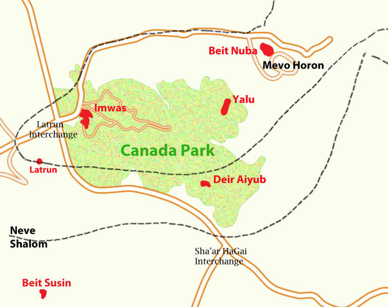
| Description | Canada Park, Israel/West Bank, showing former villages and armistice lines |
| Date | |
| Source | Own work |
| Author | Zero0000 |
Based on:
- Google Maps for modern road positions, and Israeli localities.
- National Park map for park boundaries
- 1943 survey map (South Levant, 1:50000) for former village locations.
- 1950s topographic map (Ramle, 1:100000) of the Survey of Israel for armistice lines.
Licensing
I, the copyright holder of this work, hereby publish it under the following licenses:
 | Permission is granted to copy, distribute and/or modify this document under the terms of the GNU Free Documentation License, Version 1.2 or any later version published by the Free Software Foundation; with no Invariant Sections, no Front-Cover Texts, and no Back-Cover Texts. A copy of the license is included in the section entitled GNU Free Documentation License. |
This file is licensed under the Creative Commons Attribution 3.0 Unported license.
- You are free:
- to share – to copy, distribute and transmit the work
- to remix – to adapt the work
- Under the following conditions:
- attribution – You must give appropriate credit, provide a link to the license, and indicate if changes were made. You may do so in any reasonable manner, but not in any way that suggests the licensor endorses you or your use.
You may select the license of your choice.
File history
Click on a date/time to view the file as it appeared at that time.
| Date/Time | Thumbnail | Dimensions | User | Comment | |
|---|---|---|---|---|---|
| current | 12:49, 30 November 2011 | | 828 × 656 (92 KB) | Zero0000 | Adjusted armistice lines according to better source. Added Beit Susin and Latrun. |
| 13:18, 19 April 2010 |  | 707 × 618 (94 KB) | Zero0000 | {{Information |Description=Canada Park, Israel/West Bank, showing former villages and armistice lines |Source={{own}} |Date=19 April, 2010 |Author= Zero0000 |Permission= |other_versions= }} Category:Maps of Palestine [[Category:Maps |
File usage
The following pages on the English Wikipedia use this file (pages on other projects are not listed):
Global file usage
The following other wikis use this file:
- Usage on ar.wikipedia.org
- Usage on bn.wikipedia.org
- Usage on cs.wikipedia.org
- Usage on es.wikipedia.org
- Usage on fr.wikipedia.org
- Usage on nl.wikipedia.org
- Usage on no.wikipedia.org
- Usage on pt.wikipedia.org
- Usage on uk.wikipedia.org