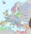
File:Europe in 1345.png

Size of this preview: 552 × 600 pixels. Other resolutions: 221 × 240 pixels | 442 × 480 pixels | 707 × 768 pixels | 1,075 × 1,168 pixels.
Original file (1,075 × 1,168 pixels, file size: 114 KB, MIME type: image/png)
File history
Click on a date/time to view the file as it appeared at that time.
| Date/Time | Thumbnail | Dimensions | User | Comment | |
|---|---|---|---|---|---|
| current | 19:31, 10 May 2020 |  | 1,075 × 1,168 (114 KB) | Santasa99 | Corrections per Euroatlas - Historical Maps, http://www.euratlas.net/history/europe/1300/index.html Euratlas Periodis Web - Map of Europe in Year 1300 |
| 12:58, 24 December 2017 |  | 1,075 × 1,168 (289 KB) | Trey Kincaid | Changed Sicily who had his own kingdom | |
| 19:30, 1 July 2012 |  | 1,075 × 1,168 (282 KB) | Ludde23 | Changed Estonia from the red color of Sweden to the yellow color of Denmark, since Estonia was not Swedish at this time, but belonged to Denmark until 1346. | |
| 21:34, 24 April 2009 |  | 1,075 × 1,168 (112 KB) | Alex:D | Borders corrected | |
| 18:02, 15 November 2007 |  | 1,075 × 1,168 (110 KB) | Teaandcrumpets | (changed notre dame marker) | |
| 23:03, 13 November 2007 |  | 1,075 × 1,168 (113 KB) | Teaandcrumpets | {{Information |Description= A map of Europe in 1345, showing the location of events that took place in that year. |Source=self-made from Image:Europein1328.png with GIMP |Date= 13 Nov 2007 |Author= Teaandcrumpets |Permission= |
File usage
The following 4 pages use this file:
Global file usage
The following other wikis use this file:
- Usage on fr.wikipedia.org
- Usage on sl.wikipedia.org
- Usage on smn.wikipedia.org
- Usage on ur.wikipedia.org


 French
 Deutsch