File:Kincade Fire tmo 2019297 MODIS.jpg

Original file (1,944 × 1,620 pixels, file size: 1.29 MB, MIME type: image/jpeg)

Summary

Description
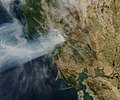
English: The Moderate Resolution Imaging Spectroradiometer (MODIS) on NASA’s Terra satellite acquired a natural-color image focusing on the smoke plume from the Kincade fire in Sonoma County as it appeared on October 24. The Kincade fire, which first ignited on October 23, raged across remote, steep terrain that was difficult to access. At least 2,000 residents of Geyserville were evacuated, and thousands of people in the region went without electric power due to planned blackouts (intended to prevent electricity-sparked fires). At 9:30 a.m. on October 25, Cal Fire reported that 21,900 acres had burned in the area, 49 structures had been destroyed, and 735 were threatened. The fire was 5 percent contained.
Date
Source

Moderate Resolution Imaging Spectroradiometer

https://earthobservatory.nasa.gov/images/145787/winds-drive-smoky-wildfires-in-california-mexico
Author NASA

Licensing

Public domain This file is in the public domain in the United States because it was solely created by NASA. NASA copyright policy states that "NASA material is not protected by copyright unless noted". (See Template:PD-USGov, NASA copyright policy page or JPL Image Use Policy.)
Warnings:

Captions

Add a one-line explanation of what this file represents

Items portrayed in this file

depicts

24 October 2019

File history

Click on a date/time to view the file as it appeared at that time.

Date/TimeThumbnailDimensionsUserComment
current07:04, 27 October 2019Thumbnail for version as of 07:04, 27 October 20191,944 × 1,620 (1.29 MB)SevgonlernassauUser created page with UploadWizard

The following page uses this file:

Global file usage

The following other wikis use this file: