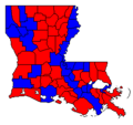
File:LASen96Counties.png
LASen96Counties.png (246 × 231 pixels, file size: 3 KB, MIME type: image/png)
File history
Click on a date/time to view the file as it appeared at that time.
| Date/Time | Thumbnail | Dimensions | User | Comment | |
|---|---|---|---|---|---|
| current | 00:13, 21 March 2021 |  | 246 × 231 (3 KB) | Calthrina950 | Reverted to version as of 04:27, 26 February 2021 (UTC) |
| 00:09, 21 March 2021 |  | 1,000 × 1,176 (73 KB) | Calthrina950 | Map of Louisiana parishes. | |
| 04:27, 26 February 2021 |  | 246 × 231 (3 KB) | Calthrina950 | Reverted to version as of 01:33, 26 February 2021 (UTC) | |
| 04:26, 26 February 2021 |  | 1,000 × 943 (108 KB) | Calthrina950 | Reverted to version as of 01:32, 26 February 2021 (UTC) | |
| 01:33, 26 February 2021 |  | 246 × 231 (3 KB) | Calthrina950 | Reverted to version as of 20:26, 7 January 2011 (UTC) | |
| 01:32, 26 February 2021 |  | 1,000 × 943 (108 KB) | Calthrina950 | Revised map. | |
| 20:26, 7 January 2011 |  | 246 × 231 (3 KB) | File Upload Bot (Magnus Manske) | {{BotMoveToCommons|en.wikipedia|year={{subst:CURRENTYEAR}}|month={{subst:CURRENTMONTHNAME}}|day={{subst:CURRENTDAY}}}} {{Information |Description={{en|Self-created image showing county-by-county results of the 1996 US Senate election in Louisiana}} |Sour |
File usage
The following page uses this file:


 French
 Deutsch