
 French
 Deutsch
File:Landgebiete der Freien Stadt Bremen.png

Size of this preview: 418 × 599 pixels. Other resolutions: 167 × 240 pixels | 335 × 480 pixels | 918 × 1,316 pixels.
Original file (918 × 1,316 pixels, file size: 76 KB, MIME type: image/png)
| This is a file from the Wikimedia Commons. Information from its description page there is shown below. Commons is a freely licensed media file repository. You can help. |
Summary
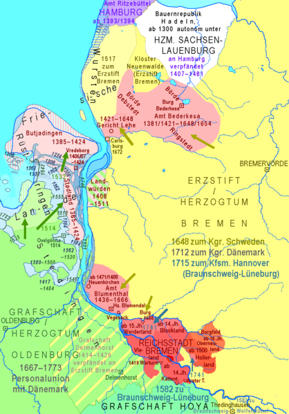
| Description | Deutsch: Landgebiete der Freien Hansestadt Bremen im 14. bis 18. Jahrhundert; Einbruchsdelta zwischen Unterweser und Jade im 14. bis 16. Jahrhundert English: Territories of the Free City of Bremen in 14th to 18th centuries |
| Date | |
| Source | Own work |
| Author | Ulamm (talk) 23:44, 29 December 2013 (UTC) |
Verwendete Quellen:
- Topografische Karte 1:100 000
- Grafschaft Oldenburg 1579/1584
- Grafschaft Oldenburg 1621/1650
- File:Karte Unterweser.jpg unbekannter Provenienz
- DUCATUS BREMÆ & FERDÆ per Fredericum de Wit (Die Karte wird an anderer Stelle auf 1715 datiert, aber das muss ein Nachdruck sein.)
- de:Landdrostei Stade wegen Amt Beverstedt + Amt Bederkesa = Amt Lehe
- Hannoversche Landesaufnahme 1764–1786
- Bremer Landesaufnahme von 1798 (Staatsarchiv Bremen)
- Kartenarchiv der Universität Greifswald archive copy at the Wayback Machine:
- Messtischblatt Bremen und Nachbarblätter (wegen der fantastischen Südgrenze von Delmenhorst bei de Wit),
- Messtischblatt Kirchenrodt (Rodenkirchen, wegen Landwührden)
- http://www.lb-oldenburg.de/pdf_oldenburger_jahrbuch/28_1924.pdf Oldenburger Jahrbuch 1924 des Vereins für Altertumskunde Bd. 28 (1924), § 11. Der Linebrok](PDF)
- Jahrbuch der Männer vom Morgenstern Bd. 56: Topographische und statistische Übersicht der Verwaltungsbezirke des Erzstifts Bremen 1752/53
- (geschichtsatlas.de: Sturmfluten archive copy at the Wayback Machine) → inzwischen verlassen, weil überholt
- Geodatenzentrum Hannover → Bodenkunde → Bodenübersichtskarte 1:50 000
- Bildergalerie Diepholz: Burg Freudenberg
- de:Grafschaft Hoya
- de:Thedinghausen
- Niedersächsischer Landesbetrieb für Wasserwirtschaft, Küsten- und Naturschutz (NLWKN): Wasserrahmenrichtlinie Band 3, Teil B Stillgewässer, Anhang II – Seeberichte: Bederkesaer See (per Google gefunden)
- Karl-Ernst Behre: Die Geschichte der Landschaft um den Jadebusen, Brune-Mettker GmbH, Wilhelmshaven 2012, ISBN 978-3-941929-02-9
Licensing
I, the copyright holder of this work, hereby publish it under the following license:
This file is licensed under the Creative Commons Attribution-Share Alike 3.0 Unported license.
- You are free:
- to share – to copy, distribute and transmit the work
- to remix – to adapt the work
- Under the following conditions:
- attribution – You must give appropriate credit, provide a link to the license, and indicate if changes were made. You may do so in any reasonable manner, but not in any way that suggests the licensor endorses you or your use.
- share alike – If you remix, transform, or build upon the material, you must distribute your contributions under the same or compatible license as the original.
File history
Click on a date/time to view the file as it appeared at that time.
| Date/Time | Thumbnail | Dimensions | User | Comment | |
|---|---|---|---|---|---|
| current | 08:53, 12 March 2014 | | 918 × 1,316 (76 KB) | Ulamm | polished |
| 21:36, 11 March 2014 |  | 918 × 1,316 (76 KB) | Ulamm | historical geography of Butjadingen and Stadland corrected after intensive research, see file:JadeWeser.png | |
| 23:58, 20 January 2014 |  | 918 × 1,316 (73 KB) | Ulamm | Weser islands and Wursten coast | |
| 21:09, 18 January 2014 |  | 918 × 1,316 (71 KB) | Ulamm | + Inte-branch of Ahne | |
| 20:45, 17 January 2014 |  | 918 × 1,316 (71 KB) | Ulamm | Hoffe island | |
| 21:33, 16 January 2014 |  | 918 × 1,316 (71 KB) | Ulamm | - Borgfeld castle + Arster Turm | |
| 15:19, 16 January 2014 |  | 918 × 1,316 (71 KB) | Ulamm | Lockfleet broader + coastline near Atens | |
| 18:09, 15 January 2014 |  | 918 × 1,316 (71 KB) | Ulamm | * Landwürden ohne h * Börden des Amtes bederkesa | |
| 19:06, 13 January 2014 |  | 918 × 1,316 (70 KB) | Ulamm | Neuenwalde, Kleine Wümme and the colour of some ancient water surfaces | |
| 15:28, 13 January 2014 |  | 918 × 1,316 (69 KB) | Ulamm | Burhave |
File usage
The following pages on the English Wikipedia use this file (pages on other projects are not listed):
Global file usage
The following other wikis use this file:
- Usage on cs.wikipedia.org
- Usage on de.wikipedia.org
- Usage on es.wikipedia.org
- Usage on fr.wikipedia.org
- Usage on nl.wikipedia.org
- Usage on ru.wikipedia.org
- Usage on sl.wikipedia.org
- Usage on sv.wikipedia.org
- Usage on tl.wikipedia.org