
 French
 Deutsch
File:Mixtecos.png

Size of this preview: 800 × 587 pixels. Other resolutions: 320 × 235 pixels | 640 × 470 pixels | 1,031 × 757 pixels.
Original file (1,031 × 757 pixels, file size: 1.01 MB, MIME type: image/png)
| This is a file from the Wikimedia Commons. Information from its description page there is shown below. Commons is a freely licensed media file repository. You can help. |
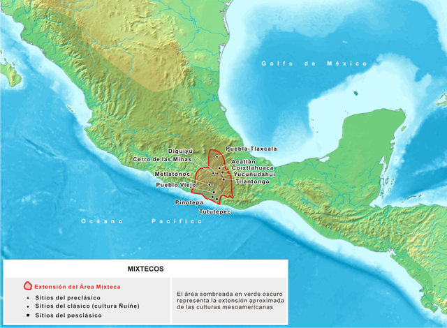
| Description | Español: Mapa donde se detallan los sitios asociados a la cultura mixteca, que se desarolló en Mesoamérica entre los siglos XV adC y XVI dC | ||
| Date | 23 noviembre | ||
| Source | Trabajo propio, basado en cartografía producida por Koba-chan | ||
| Author | Yavidaxiu | ||
| Permission (Reusing this file) |
|
File history
Click on a date/time to view the file as it appeared at that time.
| Date/Time | Thumbnail | Dimensions | User | Comment | |
|---|---|---|---|---|---|
| current | 16:51, 25 November 2006 | | 1,031 × 757 (1.01 MB) | Yavidaxiu | {{Information |Description={{es|Mapa de la extensión y ubicación de los principales sitios arqueológicos de la cultura mixteca, de los períodos Preclásico, Clásico y Posclásico de Mesoamérica.}} |Source=Trabajo propio, basado en cartografía prod |
| 20:03, 20 April 2006 |  | 1,074 × 789 (1.2 MB) | Yavidaxiu | Mapa de ubicación del territorio de la cultura mixteca. Category:Maps of México |
File usage
The following page uses this file:
Global file usage
The following other wikis use this file:
- Usage on af.wikipedia.org
- Usage on bs.wikipedia.org
- Usage on es.wikipedia.org
- Usage on fi.wikipedia.org
- Usage on fi.wikibooks.org
- Usage on fr.wiktionary.org
- Usage on gl.wikipedia.org
- Usage on hr.wikipedia.org
- Usage on ms.wikipedia.org
- Usage on zh.wikipedia.org