
 French
 Deutsch
File:Punjab-Districts 1911.png
No higher resolution available.
Punjab-Districts_1911.png (569 × 448 pixels, file size: 113 KB, MIME type: image/png)
| This is a file from the Wikimedia Commons. Information from its description page there is shown below. Commons is a freely licensed media file repository. You can help. |
Summary
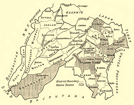
| Description | English: Map of the Districts and some Indian Princely States (Bahawalpur, Sirmur, Suket, Chamba etc.) of the Punjab, 1911 Deutsch: Karte der Distrikte des Punjab und einiger darin eingeschlossener indischer Fürstenstaaten (Bahawalpur, Sirmur, Suket, Chamba ), 1911. Höhenangaben in Fuß. |
| Date | |
| Source | Provincial Geographies of India, Vol. III |
| Author | Sir Henry |
Licensing
| This work is in the public domain in its country of origin and other countries and areas where the copyright term is the author's life plus 70 years or fewer. | |
| This file has been identified as being free of known restrictions under copyright law, including all related and neighboring rights. | |
File history
Click on a date/time to view the file as it appeared at that time.
| Date/Time | Thumbnail | Dimensions | User | Comment | |
|---|---|---|---|---|---|
| current | 08:12, 29 June 2014 | | 569 × 448 (113 KB) | Xufanc | sepia color |
| 15:36, 18 January 2010 |  | 569 × 448 (149 KB) | Zenwort | {{Information |Description={{en|1=Map of the Districts and some Indian Princely States of the Punjab, 1911}} {{de|1=Karte der Distrikte des Punjab und einiger darin eingeschlossener indischer Fürstenstaaten, 1911. Höhenangaben in Fuß.}} |Source=Provinc |
File usage
The following 7 pages use this file:
Global file usage
The following other wikis use this file:
- Usage on bn.wikipedia.org
- Usage on ca.wikipedia.org
- Usage on de.wikipedia.org
- Usage on es.wikipedia.org
- Usage on fr.wikipedia.org
- Usage on hi.wikipedia.org
- Usage on id.wikipedia.org
- Usage on it.wikipedia.org
- Usage on pa.wikipedia.org
- Usage on pnb.wikipedia.org
- Usage on ru.wikipedia.org
- Usage on ta.wikipedia.org
- Usage on ur.wikipedia.org
- Usage on www.wikidata.org