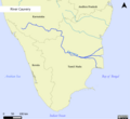
File:River Cauvery EN.png

Size of this preview: 652 × 599 pixels. Other resolutions: 261 × 240 pixels | 522 × 480 pixels | 836 × 768 pixels | 1,114 × 1,024 pixels | 1,653 × 1,519 pixels.
Original file (1,653 × 1,519 pixels, file size: 504 KB, MIME type: image/png)
File history
Click on a date/time to view the file as it appeared at that time.
| Date/Time | Thumbnail | Dimensions | User | Comment | |
|---|---|---|---|---|---|
| current | 14:15, 25 January 2014 |  | 1,653 × 1,519 (504 KB) | NaanCoder | Added graticules to the map. |
| 13:55, 25 January 2014 |  | 1,653 × 1,514 (486 KB) | NaanCoder | Color scheme based on WikiProject Maps guidelines. Added OSM attribution. | |
| 06:56, 16 January 2014 |  | 2,480 × 2,271 (743 KB) | NaanCoder | Improved the river data from Natural Earth to OpenStreetMap. Changed the fonts and styling. | |
| 17:20, 15 January 2014 |  | 2,480 × 2,267 (371 KB) | NaanCoder | User created page with UploadWizard |
File usage
The following page uses this file:
Global file usage
The following other wikis use this file:
- Usage on azb.wikipedia.org
- Usage on bh.wikipedia.org
- Usage on br.wikipedia.org
- Usage on de.wikipedia.org
- Usage on el.wikipedia.org
- Usage on en.wikinews.org
- Usage on eo.wikipedia.org
- Usage on es.wikipedia.org
- Usage on fa.wikipedia.org
- Usage on fi.wikipedia.org
- Usage on fr.wikipedia.org
- Usage on hi.wikipedia.org
- Usage on hu.wikipedia.org
- Usage on id.wikipedia.org
- Usage on ko.wikipedia.org
- Usage on mai.wikipedia.org
- Usage on nl.wikipedia.org
- Usage on no.wikipedia.org
- Usage on sl.wikipedia.org
- Usage on sr.wikipedia.org
- Usage on th.wikipedia.org
- Usage on tr.wikipedia.org


 French
 Deutsch