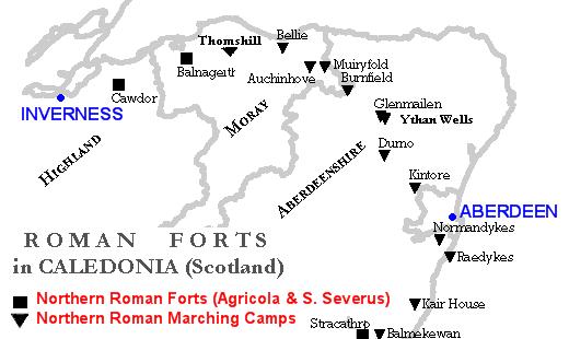
File:RomanFortsNorthernScotland.gif
RomanFortsNorthernScotland.gif (520 × 310 pixels, file size: 12 KB, MIME type: image/gif)
File history
Click on a date/time to view the file as it appeared at that time.
| Date/Time | Thumbnail | Dimensions | User | Comment | |
|---|---|---|---|---|---|
| current | 02:54, 25 July 2009 |  | 520 × 310 (12 KB) | Paul0559 | {{Information |Description={{en|1=Map of Northern Caledonia (Scotland) showing Roman Forts and Marching Camps (little forts) during the Agricola Campaign (first century) and the Septimius Severus Campaign (third century). Map and data done with my own sof |
File usage
The following page uses this file:
Global file usage
The following other wikis use this file:
- Usage on es.wikipedia.org
- Usage on it.wikipedia.org
- Vallo Antonino
- Battaglia del monte Graupio
- Campagne in Britannia di Agricola
- Gask Ridge
- Cawdor (accampamento romano)
- Forti e accampamenti romani a nord del Gask Ridge
- Raedykes
- Stracathro
- Balnageith
- Glenmailen
- Ythan Wells
- Muiryfold
- Auchinhove
- Thomshill
- Bellie
- Normandykes
- Balmakewan
- Template:Conquista romana della Caledonia settentrionale
- Kair House
- Kintore (Regno Unito)
- Durno
- Burnfield


 French
 Deutsch