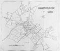
File:Sandbach town centre map 1840.png

Original file (2,379 × 2,041 pixels, file size: 1.77 MB, MIME type: image/png)

Summary

Description
English: 1840 vintage old map of Sandbach town centre, Cheshire. Features roads to Bradwall, Congleton, Smallwood, Newcastle under Lyme, Wheelock, and Middlewich. Also Offley Road, Scotch Common, High Street, London Road and Union Street. Also the Brick Kiln, National School, St Mary's Church, Gas Works and Pool. Land holdings by Mr Beddalls, Mr J Wood, Mr Williams, Mr Wilson, Mr Barlon (Barton?), Mr John Ball, Mr J Lowe, Mr Reddall, Mr Sharrott, and Trustees of St Mary's Church. Field House, Cold Moss Heath. Shows a Scale of Chains.
Date
Source Own work
Author Iantresman
Camera location53° 08′ 45.6″ N, 2° 22′ 01.2″ W Kartographer map based on OpenStreetMap.View this and other nearby images on: OpenStreetMapinfo

Now in the public domain

Licensing

Public domain

This work is in the public domain in its country of origin and other countries and areas where the copyright term is the author's life plus 70 years or fewer.


You must also include a United States public domain tag to indicate why this work is in the public domain in the United States.
This file has been identified as being free of known restrictions under copyright law, including all related and neighboring rights.

Captions

Add a one-line explanation of what this file represents

Items portrayed in this file

depicts

1 January 1840Gregorian

File history

Click on a date/time to view the file as it appeared at that time.

Date/TimeThumbnailDimensionsUserComment
current15:56, 15 September 2016Thumbnail for version as of 15:56, 15 September 20162,379 × 2,041 (1.77 MB)IantresmanUser created page with UploadWizard
No pages on the English Wikipedia use this file (pages on other projects are not listed).

Metadata