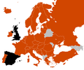
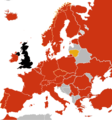
File:Swine flu Europe map.png

Size of this preview: 720 × 600 pixels. Other resolutions: 288 × 240 pixels | 576 × 480 pixels | 922 × 768 pixels | 1,229 × 1,024 pixels | 2,458 × 2,048 pixels.
Original file (2,458 × 2,048 pixels, file size: 413 KB, MIME type: image/png)
File history
Click on a date/time to view the file as it appeared at that time.
| Date/Time | Thumbnail | Dimensions | User | Comment | |
|---|---|---|---|---|---|
| current | 17:29, 5 September 2022 |  | 2,458 × 2,048 (413 KB) | Рагин1987 | Extended map |
| 07:53, 4 July 2009 |  | 560 × 599 (81 KB) | Vatrena ptica~commonswiki | update | |
| 12:20, 30 June 2009 |  | 560 × 599 (81 KB) | Vatrena ptica~commonswiki | update BiH and Spain | |
| 17:18, 27 June 2009 |  | 560 × 599 (81 KB) | Richhaddon | updated slovenia | |
| 17:16, 27 June 2009 |  | 560 × 599 (81 KB) | Richhaddon | updated lativa,lithuania | |
| 20:55, 24 June 2009 |  | 560 × 599 (81 KB) | Vatrena ptica~commonswiki | added Serbia | |
| 00:21, 24 June 2009 |  | 560 × 599 (81 KB) | Fonadier | Added Montenegro | |
| 12:38, 21 June 2009 |  | 560 × 599 (81 KB) | Vatrena ptica~commonswiki | update Slovenia | |
| 08:49, 16 June 2009 |  | 560 × 599 (81 KB) | Vatrena ptica~commonswiki | trying again | |
| 08:49, 16 June 2009 |  | 560 × 599 (81 KB) | Vatrena ptica~commonswiki | trying again |
File usage
The following 5 pages use this file:
Global file usage
The following other wikis use this file:
- Usage on es.wikipedia.org
- Usage on fr.wikipedia.org


 French
 Deutsch
