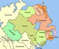
File:Ulster Early 16th Century.png
Ulster_Early_16th_Century.png (510 × 425 pixels, file size: 43 KB, MIME type: image/png)
File history
Click on a date/time to view the file as it appeared at that time.
| Date/Time | Thumbnail | Dimensions | User | Comment | |
|---|---|---|---|---|---|
| current | 22:28, 24 June 2010 |  | 510 × 425 (43 KB) | Mabuska | New map, better colours |
| 14:01, 24 June 2010 |  | 512 × 427 (45 KB) | Mabuska | Re-added the lines for the smaller areas | |
| 13:55, 24 June 2010 |  | 510 × 425 (43 KB) | Mabuska | fixed County Fermanagh border with Donegal | |
| 12:02, 24 June 2010 |  | 512 × 427 (45 KB) | Mabuska | {{Information |Description = Lordships of Ulster early 16th century |Source = I (~~~) created this work entirely by myself. |Date = ~~~~~ |Author = ~~~ |other_versions = }} |
File usage
The following 9 pages use this file:
Global file usage
The following other wikis use this file:
- Usage on es.wikipedia.org
- Usage on eu.wikipedia.org
- Usage on ga.wikipedia.org
- Usage on pt.wikipedia.org
- Usage on www.wikidata.org


 French
 Deutsch