
 French
 Deutsch
File:World Map 1689.JPG

Size of this preview: 695 × 600 pixels. Other resolutions: 278 × 240 pixels | 556 × 480 pixels | 890 × 768 pixels | 1,186 × 1,024 pixels | 2,373 × 2,048 pixels | 4,560 × 3,936 pixels.
Original file (4,560 × 3,936 pixels, file size: 8.59 MB, MIME type: image/jpeg)
| This is a file from the Wikimedia Commons. Information from its description page there is shown below. Commons is a freely licensed media file repository. You can help. |
| This is a featured picture, which means that members of the community have identified it as one of the finest images on the English Wikipedia, adding significantly to its accompanying article. If you have a different image of similar quality, be sure to upload it using the proper free license tag, add it to a relevant article, and nominate it. |
| This image was selected as picture of the day on the English Wikipedia for September 18, 2013. |
|

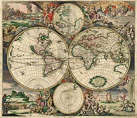
This image was selected as picture of the day on Wikimedia Commons for 7 February 2007. It was captioned as follows: English: An old world map produced in Amsterdam in 1689. Other languages: Deutsch: Eine 1689 in Amsterdam hergestellte Weltkarte. English: An old world map produced in Amsterdam in 1689. Polski: Mapa świata wyprodukowana w Amsterdamie w roku 1689. Suomi: Hollantilainen maailmankartta vuodelta 1689 Svenska: En gammal världskarta tillverkad i Amsterdam 1689. Winaray: In kahadto nga mapa han kalibutan nga ginhimo ha Amsterdam, 1689. Српски / srpski: Стара карта света направљена у Амстердаму 1689. עברית : מפת עולם משנת 1689 מאמסטרדם |
| This image was selected as a picture of the week on the Persian Wikipedia for the 21st week, 2011. |
Summary
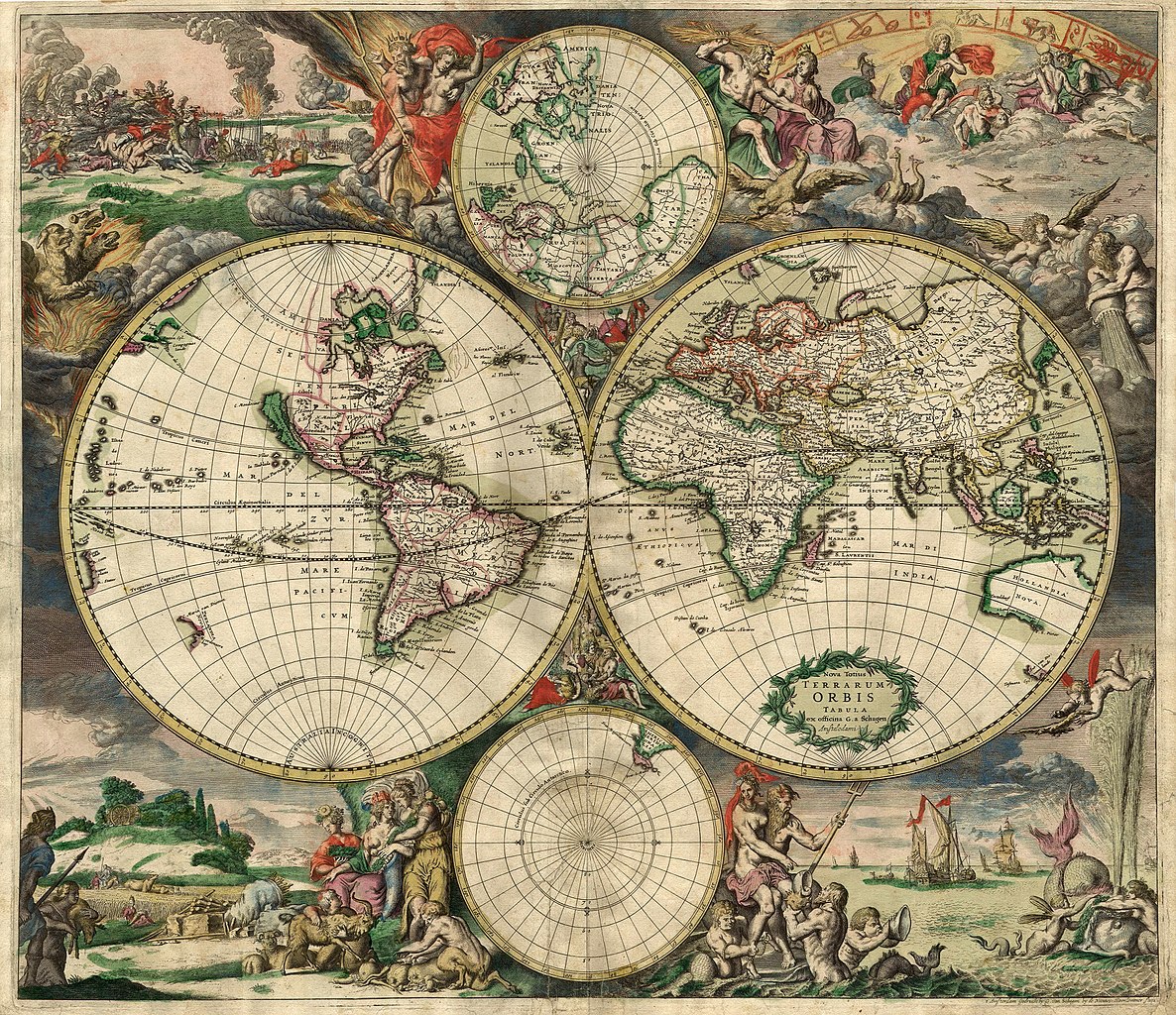
| Description | Nederlands: Nova totius terrarum orbis tabula Amstelodami, ex officina G. a Schagen (1682), t'Amsterdam Gedruckt by G. van Schagen, by de Nieuwe Haerlemmer Sluys. English: World map - Produced in Amsterdam First edition : 1689. Original size : 48.3 x 56.0 cm. Produced using copper engraving. Extremely rare set of maps, only known in one other example in the Amsterdam University. No copies in American libraries. In original hand color. Français : Carte du monde - Créée à Amsterdam Première édition : 1689. Taille originale : 48,3 x 56,0 cm. Eau forte. |
| Date | This edition 1689 |
| Source | This image is made up of six separate images downloaded from Helmink.com and stitched together. |
| Creator | |
| Permission (Reusing this file) | Public Domain |
| Georeferencing | If inappropriate please set warp_status = skip to hide. |
| Other versions | Image:World Map 1689-smaller.jpg (smaller filesize version, easier to download) |
.JPG)
Licensing
| This work is in the public domain in its country of origin and other countries and areas where the copyright term is the author's life plus 70 years or fewer. | |
| This file has been identified as being free of known restrictions under copyright law, including all related and neighboring rights. | |
File history
Click on a date/time to view the file as it appeared at that time.
| Date/Time | Thumbnail | Dimensions | User | Comment | |
|---|---|---|---|---|---|
| current | 00:59, 4 September 2013 | | 4,560 × 3,936 (8.59 MB) | Crisco 1492 | Reverted to version as of 12:34, 16 October 2010 |
| 00:47, 4 September 2013 |  | 4,560 × 3,936 (19.56 MB) | Crisco 1492 | Reverted to version as of 01:01, 30 November 2006 Per Commons:Overwriting existing files, do not overwrite featured images | |
| 12:34, 16 October 2010 |  | 4,560 × 3,936 (8.59 MB) | Brandmeister~commonswiki | slight adjustment | |
| 01:01, 30 November 2006 |  | 4,560 × 3,936 (19.56 MB) | Tarawneh | == Summary == {{Information |Description= World map - Produced in Amsterdam<br> FIRST edition : 1689 <br> Original size : 48.3 x 56.0 cm <br> Produced using copper engraving |Source= scanned copy |Date= This edition 1689 |Author= van Schagen |Permission |
File usage
The following pages on the English Wikipedia use this file (pages on other projects are not listed):
- Early world maps
- Gerard van Schagen
- History of navigation
- World map
- Talk:World map
- User:Arjuno3/Books/Navigation
- User:Cg2727/sandbox
- User:Mohit Agarwal
- User:Truth'soutthere
- User:VGrigas (WMF)/Quality Media
- User:Viatorem2k
- User talk:Bewareofdog
- User talk:Bewareofdog/Archive 1
- User talk:MathewTownsend/Archive 3
- Wikipedia:Featured picture candidates/March-2007
- Wikipedia:Featured picture candidates/World Map
- Wikipedia:Featured picture candidates/delist/2007
- Wikipedia:Featured picture candidates/delist/Image:World Map 1689.JPG
- Wikipedia:Featured pictures/Diagrams, drawings, and maps/Maps
- Wikipedia:Featured pictures thumbs/06
- Wikipedia:Main Page history/2013 September 18
- Wikipedia:Picture of the day/September 2013
- Wikipedia:Reference desk/Miscellaneous/February Werdnabot Archives
- Wikipedia:WikiProject Netherlands
- Wikipedia:Wikipedia Signpost/2007-03-12/Features and admins
- Wikipedia:Wikipedia Signpost/2007-03-12/SPV
- Wikipedia:Wikipedia Signpost/2012-04-30/WikiProject report
- Wikipedia:Wikipedia Signpost/Single/2007-03-12
- Wikipedia:Wikipedia Signpost/Single/2012-04-30
- Wikipedia:Wikipedia for Schools/Welcome
- Template:POTD/2013-09-18
- Portal:Geography/Selected picture
- Portal:Maps
- Portal:Maps/Intro
- Portal:Maps/Selected picture
- Portal:Maps/Selected picture/8
- Portal:Netherlands
- Portal:Netherlands/Featured content
Global file usage
The following other wikis use this file:
- Usage on af.wikipedia.org
- Usage on ar.wikipedia.org
- Usage on ba.wikipedia.org
- Usage on bg.wikipedia.org
- Usage on bg.wikiquote.org
- Usage on bjn.wikipedia.org
- Usage on bn.wikipedia.org
- Usage on bs.wikipedia.org
- Usage on ca.wikipedia.org
- Usage on ce.wikipedia.org
- Usage on crh.wikipedia.org
- Usage on cs.wikipedia.org
- Usage on cv.wikipedia.org
- Usage on de.wikipedia.org
- Usage on el.wikipedia.org
View more global usage of this file.