Geeste (river)
| Geeste | |
|---|---|
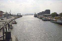
 The mouth of the Geeste at Bremerhaven | |
 | |
| Location | |
| Country | Germany |
| State | Lower Saxony |
| Physical characteristics | |
| Mouth | |
• location | Weser |
• coordinates | 53°32′15″N 8°34′55″E / 53.53750°N 8.58194°E |
| Length | 40.1 km (24.9 mi)[1] |
| Basin size | 338 km2 (131 sq mi)[1] |
| Basin features | |
| Progression | Weser→ North Sea |
The Geeste is a river in Lower Saxony, Germany. It rises near the village of Hipstedt and falls into the Weser at Bremerhaven after a course of some 40 km (25 mi). It is the Weser's lowest tributary. The lower reaches of the Geeste are navigable and form part of the Elbe–Weser waterway.[2]
A barrier system at Bremerhaven prevents storm surges from moving up the Geeste and flooding the surrounding districts. This was completed in 1961, just in time for the North Sea flood of 1962.[3]
- The Geeste near its source
- The river's junction with the Elbe canal
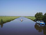
- A vessel motoring along the Geeste
- Sluice at Bremerhaven
- Meander at Bremerhaven
See also
[edit]References
[edit]Wikimedia Commons has media related to Geeste (river).
- ^ a b Environmental map service of Lower Saxony (Umweltkartendienst des Niedersächsischen Ministeriums für Umwelt, Energie und Klimaschutz)
- ^ "Kanufahren auf der Geeste" (in German). Reiseland Niedersachsen. Retrieved 29 January 2024.
- ^ "Küstenschutz Band 3" (PDF) (in German). Niedersächsischer Landesbetrieb für Wasserwirtschaft, Küsten- und Naturschutz. 2020. p. 5. Retrieved 29 January 2024.


 French
 Deutsch


