Ireteba Peaks Wilderness
| Ireteba Peaks Wilderness | |
|---|---|
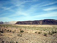
 Landscape of Iretaba Peaks Wilderness | |
| Location | Clark County, Nevada, USA |
| Nearest city | Las Vegas, NV |
| Coordinates | 35°35′39.96″N 114°49′43.92″W / 35.5944333°N 114.8288667°W |
| Area | 32,745 acres (132.51 km2) |
| Established | 2002 |
| Governing body | National Park Service, Bureau of Land Management |
Ireteba Peaks Wilderness is a 32,745 acre (13,251 ha) wilderness area spanning the area of the southern part of Eldorado Mountains to the northern parts of Lake Mohave. It is located 45 miles (72 km) south of Las Vegas and was designated as a wilderness area in 2002.[1] Iretaba Peaks Wilderness is managed by the National Park Service and the Bureau of Land Management.[2] The western (BLM) portion of the wilderness is part of Avi Kwa Ame National Monument, designated in 2023.
Geography
[edit]The peaks were named after one of the leaders of the Mohave tribe, Irataba.[3] Native vegetation in the area includes creosote, yucca, desert willow, and several cacti species.[1] Desert tortoises, Townsend’s big-eared bats, and bighorn sheep can also be found in Iretaba Peaks Wilderness.[4]
See also
[edit]References
[edit]- ^ a b "Ireteba Peaks Wilderness Fact Sheet" (PDF). Bureau of Land Management.
- ^ "Ireteba Peaks Wilderness - Lake Mead National Recreation Area (U.S. National Park Service)". National Park Service. Retrieved 2021-09-16.
- ^ "Ireteba Peaks Wilderness". Friends of Nevada Wilderness. Retrieved 2021-09-16.
- ^ "Ireteba Peaks Wilderness". wilderness.net. Retrieved 2021-09-16.


 French
 Deutsch