Jheringsfehn
Jheringsfehn | |
|---|---|
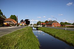
 Double-beam drawbridge in Jheringsfehn | |
| Coordinates: 53°19′07″N 7°31′04″E / 53.31849°N 7.51786°E | |
| Country | Germany |
| State | Lower Saxony |
| District | Leer |
| Municipality | Moormerland |
| Area | |
| • Village of Moormerland | 10.55 km2 (4.07 sq mi) |
| Elevation | 2 m (7 ft) |
| Population | |
| • Metro | 2,440 |
| Time zone | UTC+01:00 (CET) |
| • Summer (DST) | UTC+02:00 (CEST) |
| Postal codes | 26802 |
| Dialling codes | 04954 |
Jheringsfehn (frequently misspelt Iheringsfehn) is a peat village in the region of East Frisia, in Lower Saxony, Germany. Administratively, it is an Ortsteil of the municipality of Moormerland. Warsingsfehn is located just to the east of Warsingsfehn and is approximately 10 kilometers to the northeast of Leer. It has a population of 2,440.
The village was named in 1754 after Sebastian Eberhard Jhering, great-grandfather of Rudolf von Jhering. The village still has its classic peat canals.[1] Important elements of village life are the local sports club and the Lutheran church, which also covers the neighbouring village of Boekzetelerfehn.[2][3] The village church stands on the boundary between the two villages.
References
[edit]- ^ "Flurnamentour Jheringsfehn - flurnamen ostfriesland". Ostfriesische Landschaft (in German). Retrieved 8 March 2024.
- ^ "Jherings-Boekzetelerfehn". Kirchengemeindelexikon (in German). Retrieved 8 March 2024.
- ^ "VFL Jheringsfehn". VFL Jheringsfehn. Retrieved 8 March 2024.


 French
 Deutsch

